IMAGES TAKEN NEAR TO
Stow Road, CHIPPING NORTON, OX7 6XH
Introduction
This page details the photographs taken nearby to Stow Road, OX7 6XH by members of the Geograph project.
The Geograph project started in 2005 with the aim of publishing, organising and preserving representative images for every square kilometre of Great Britain, Ireland and the Isle of Man.

There are currently over 7.5m images from over14,400 individuals and you can help contribute to the project by visiting https://www.geograph.org.uk
Image Map (Loading...)


Getting Data...Please wait
Leaflet Map data © OpenStreetMap
Images are licensed for reuse under creativecommons.org/licenses/by-sa/2.0
Notes
- Clicking on the map will re-center to the selected point.
- The higher the marker number, the further away the image location is from the centre of the postcode.
Image Listing (45 Images Found)
Images are licensed for reuse under creativecommons.org/licenses/by-sa/2.0
Image
Details
Distance
1
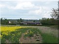
Banks Farm
Seen, across the fields, from the footpath to Gawcombe.
Image: © Michael Dibb
Taken: 15 May 2010
0.05 miles
3
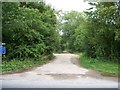
Track to the railway
Starting from the B4450, the track is a restricted byway as far as the dismantled railway at which point it becomes a bridleway to Lower Oddington.
Image: © Michael Dibb
Taken: 24 Jul 2010
0.07 miles
4
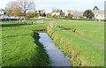
Bledington Village Green
Showing a detail of the various ditches that intersect the green. A spring is shown on the map just west of here, and the green itself is in the bottom of a shallow valley, so presumably it needs a lot of draining to stop it becoming the Village Swamp.
Image: © Des Blenkinsopp
Taken: 21 Jul 2012
0.08 miles
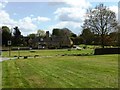
6
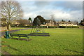
Green, Bledington
Looking left from where Image] was taken, showing the swings and seat. Partly obscured by a conifer in the background is the listed Gilberts Farmhouse https://www.historicengland.org.uk/listing/the-list/list-entry/1089814 .
Image: © Derek Harper
Taken: 28 Jan 2017
0.09 miles
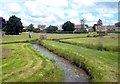
7
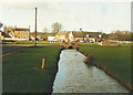
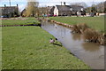
The Green, Bledington in 1987
Looking along the brook to the bridge carrying Stow Road over it. The building with car parked outside is The King's Head Inn.
Image: © John Baker
Taken: 11 Apr 1987
0.10 miles
9
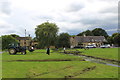
The Green at Bledington
The King's Head Inn can been seen in the background.
Image: © Philip Halling
Taken: 9 Apr 2006
0.10 miles
10
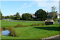
The Green, Bledington
The green is crossed by a number of drainage ditches.
Image: © Graham Horn
Taken: 13 Sep 2012
0.10 miles