IMAGES TAKEN NEAR TO
Meadow Place, CHIPPING NORTON, OX7 6PD
Introduction
This page details the photographs taken nearby to Meadow Place, OX7 6PD by members of the Geograph project.
The Geograph project started in 2005 with the aim of publishing, organising and preserving representative images for every square kilometre of Great Britain, Ireland and the Isle of Man.

There are currently over 7.5m images from over14,400 individuals and you can help contribute to the project by visiting https://www.geograph.org.uk
Image Map (48 Images)


Getting Data...Please wait
Leaflet Map data © OpenStreetMap
Images are licensed for reuse under creativecommons.org/licenses/by-sa/2.0
Notes
- Clicking on the map will re-center to the selected point.
- The higher the marker number, the further away the image location is from the centre of the postcode.
Image Listing (48 Images Found)
Images are licensed for reuse under creativecommons.org/licenses/by-sa/2.0
Image
Details
Distance
1
Notice to walkers
When close enough to read the sign it says 'Notice to all walkers. Please go back and use the footpath."
Image: © Michael Dibb
Taken: 30 Apr 2010
0.05 miles
2
![Footpath to Kingham [2]](https://s2.geograph.org.uk/geophotos/01/86/36/1863670_842a5c9f_120x120.jpg)
Footpath to Kingham [2]
The footpath leaves the village and passes through open fields.
Image: © Michael Dibb
Taken: 30 Apr 2010
0.07 miles
4
![Footpath to Kingham [3]](https://s2.geograph.org.uk/geophotos/01/86/36/1863674_3ce6a799_120x120.jpg)
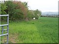
Footpath to Kingham [3]
The path continues to cross open fields. Kingham can be seen to the left whilst on the skyline can be made out the tower of the church of St Edward in Stow-on-the-Wold Image
Image: © Michael Dibb
Taken: 30 Apr 2010
0.12 miles
5
Hastings Hill House, Churchill
Hastings Hill House on Hastings Hill was the birthplace of Warren Hastings who became the first Governor-General of India (1774-85). He was born here on the 6 December 1732, here died on 22 August 1818 at nearby Daylesford House.
Image: © Philip Halling
Taken: 11 Aug 2018
0.15 miles
6
![Footpath to Kingham [1]](https://s1.geograph.org.uk/geophotos/01/86/36/1863669_0338a0e6_120x120.jpg)
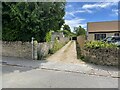
Footpath to Kingham [1]
The footpath leaves the B4055 road and initially passes along this narrow track through the village.
Image: © Michael Dibb
Taken: 30 Apr 2010
0.15 miles
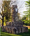
8
William Smith memorial
The plaque is shown in photograph Image
Image: © Philip Jeffrey
Taken: 10 Jul 2022
0.17 miles
9
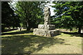
The William Smith memorial in Church Road
William 'Strata' Smith (23 March 1769 – 28 August 1839) was a geologist, credited with creating the first nationwide geological map of Britain.
Image: © Steve Daniels
Taken: 22 Apr 2017
0.17 miles
10
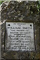
Plaque on the William Smith memorial
Image: © Philip Jeffrey
Taken: 10 Jul 2022
0.17 miles