IMAGES TAKEN NEAR TO
Elmsfield Industrial Estate, Worcester Road, CHIPPING NORTON, OX7 5XL
Introduction
This page details the photographs taken nearby to Elmsfield Industrial Estate, Worcester Road, OX7 5XL by members of the Geograph project.
The Geograph project started in 2005 with the aim of publishing, organising and preserving representative images for every square kilometre of Great Britain, Ireland and the Isle of Man.

There are currently over 7.5m images from over14,400 individuals and you can help contribute to the project by visiting https://www.geograph.org.uk
Image Map
Images are licensed for reuse under creativecommons.org/licenses/by-sa/2.0
Notes
- Clicking on the map will re-center to the selected point.
- The higher the marker number, the further away the image location is from the centre of the postcode.
Image Listing (52 Images Found)
Images are licensed for reuse under creativecommons.org/licenses/by-sa/2.0
Image
Details
Distance
1
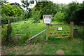
Chipping Norton Community Orchard
Anyone can come and pick their own for free.
Image: © Bill Boaden
Taken: 19 Aug 2015
0.08 miles
2
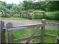
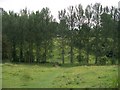
Across the driveway
As it continues to descend into the valley, the footpath crosses this driveway leading to a small estate of houses.
Image: © Michael Dibb
Taken: 24 Jun 2010
0.10 miles
3
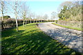
Route to Elmsfield Farm Industrial Estate
The footpath used by Shakespeare's Way crosses this road. After a few fields of muddy clay it was a relief to walk on tarmac for a few yards.
Image: © Graham Horn
Taken: 17 Feb 2013
0.12 miles
4
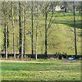
Industrial estate driveway
The footpath crosses this driveway leading to the Elmsfield Farm Industrial Estate.
Image: © Michael Dibb
Taken: 24 Jun 2010
0.12 miles
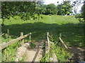
5
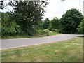
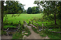
Valley bottom
The footpath crosses the small stream at the bottom of the valley and then ascends towards Chipping Norton. Another path branches off from this side of the footbridge and runs to the left to the restricted byway from Over Norton to Salford.
Image: © Michael Dibb
Taken: 24 Jun 2010
0.13 miles
6
Footbridge on Shakespeare's Way
The path is crossing the lesser of Chipping Norton's rivers, but I cannot find a name for it. All local rivers drain into the Evenlode.
Image: © Bill Boaden
Taken: 19 Aug 2015
0.13 miles
7
Footpath leaving Chipping Norton
Shakespeare's Way uses this footpath through attractive parkland on its northward departure from Chipping Norton. The slopes either side of the footbridge are steeper than they look, and very slippery. Both of us had fallen on the descent on the far side.
Image: © Graham Horn
Taken: 17 Feb 2013
0.13 miles
8
Entering Chipping Norton
Shakespeare's Way uses this footpath through this attractive parkland to enter Chipping Norton. It is a steeper slope than it looks down to the footbridge, and very slippery. Both of us slipped over here, so entered the town with very muddy backsides.
Image: © Graham Horn
Taken: 17 Feb 2013
0.13 miles
9
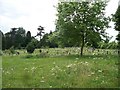
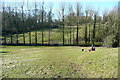
Chipping Norton Cemetery
Seen from the footpath.
Image: © Michael Dibb
Taken: 24 Jun 2010
0.14 miles
10
Shakespeare's Way
Shakespeare's Way nearing Chipping Norton
Image: © Shaun Ferguson
Taken: 4 Jul 2014
0.14 miles