IMAGES TAKEN NEAR TO
Shilson Lane, CHIPPING NORTON, OX7 3PD
Introduction
This page details the photographs taken nearby to Shilson Lane, OX7 3PD by members of the Geograph project.
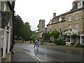
The Geograph project started in 2005 with the aim of publishing, organising and preserving representative images for every square kilometre of Great Britain, Ireland and the Isle of Man.

There are currently over 7.5m images from over14,400 individuals and you can help contribute to the project by visiting https://www.geograph.org.uk
Image Map
Images are licensed for reuse under creativecommons.org/licenses/by-sa/2.0
Notes
- Clicking on the map will re-center to the selected point.
- The higher the marker number, the further away the image location is from the centre of the postcode.
Image Listing (172 Images Found)
Images are licensed for reuse under creativecommons.org/licenses/by-sa/2.0
Image
Details
Distance
1
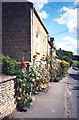
Charlbury village
Cottages in Park Street
Image: © norman griffin
Taken: 17 Jul 1993
0.04 miles
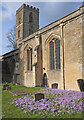
2
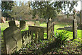
Headstones, Charlbury
This groups of memorials are close to the door of St Mary's church. Behind the wall is a listed house https://historicengland.org.uk/listing/the-list/list-entry/1053251?section=official-listing on Park Street with a date stone of 1666.
Image: © Derek Harper
Taken: 11 Feb 2022
0.05 miles
3
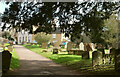
Churchyard path, Charlbury
From close to the church entrance, with houses on the bend of Church Street and Park Street. On the right are some of the headstones shown in Image
Image: © Derek Harper
Taken: 11 Feb 2022
0.05 miles
4
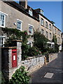
Photo of the village of Charlbury
Looking slightly up the street towards Market Street.
Image: © Dave and Carolyn Sawyer
Taken: 9 Sep 2005
0.06 miles
5
A village in Wychwood - Charlbury, Oxfordshire
The name Charlbury - Ceorl's bury (?) is said to date from Anglo Saxon times. This village beside the River Evenlode once hosted many trades and was a centre of the glove-making industry from the 1800s to the 1960s. There was once an annual fair, held on a number of sites in the village, but this was stopped in 1857 when the proceedings became too rowdy. Sadly the YHA vanished from the place some years ago. In the churchyard is the grave of a man who was killed during the making of the railway 'by a fall of earth in Sydenhams Mead'. Time photo taken 2.32 pm BST (British Summer Time)
Image: © Martin Richard Phelan
Taken: 11 Jun 2011
0.06 miles
6
Crocuses by the church, Charlbury
St Mary's church is grade I listed https://historicengland.org.uk/listing/the-list/list-entry/1053232?section=official-listing .
Image: © Derek Harper
Taken: 11 Feb 2022
0.06 miles
7
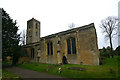
St Mary, Charlbury - south elevation
The church is Norman in origin and was much enlarged in the C13. The windows seen here are of Perpendicular age and the battlemented bell-stage of the tower was added in the C15.
Image: © David Kemp
Taken: 11 Jan 2020
0.06 miles
8
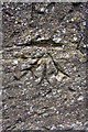
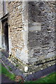
Benchmark on St Mary's Church tower
Ordnance Survey cut mark benchmark described on the Bench Mark Database at http://www.bench-marks.org.uk/bm61906
Image: © Roger Templeman
Taken: 13 Nov 2014
0.06 miles
9
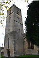
Tower of St Mary the Virgin Church
Image: © Roger Templeman
Taken: 13 Nov 2014
0.06 miles
10
SW angle of St Mary's Church Tower
An old OS benchmark Image can be seen spanning two quoins below a replaced quoin
Image: © Roger Templeman
Taken: 13 Nov 2014
0.06 miles