IMAGES TAKEN NEAR TO
OX5 1UR
Introduction
This page details the photographs taken nearby to OX5 1UR by members of the Geograph project.
The Geograph project started in 2005 with the aim of publishing, organising and preserving representative images for every square kilometre of Great Britain, Ireland and the Isle of Man.

There are currently over 7.5m images from over14,400 individuals and you can help contribute to the project by visiting https://www.geograph.org.uk
Image Map
Images are licensed for reuse under creativecommons.org/licenses/by-sa/2.0
Notes
- Clicking on the map will re-center to the selected point.
- The higher the marker number, the further away the image location is from the centre of the postcode.
Image Listing (8 Images Found)
Images are licensed for reuse under creativecommons.org/licenses/by-sa/2.0
Image
Details
Distance
1
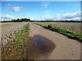
Track to Parker's Farm
Most of this square is flat farmland, but beyond the trees is the built up suburb of Kidlington.
Image: © Des Blenkinsopp
Taken: 23 Oct 2013
0.05 miles
2
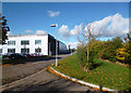
Edge of the Science Park
This is the eastern side of the Institute of Advanced Technology building on Begbroke Science Park.
The IAT is a multi used building accommodating a mix of research groups from different science based University Departments, as well as one commercially occupied wing.
Image: © Des Blenkinsopp
Taken: 23 Oct 2013
0.13 miles
3
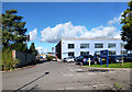
Institute of Advanced Technology
The Institute of Advanced Technology is a multi used building accommodating a mix of research groups from different science based University Departments, as well as one commercially occupied wing.
It is part of Begbroke Science Park which is run by Oxford University.
The building straddles two squares.
Image: © Des Blenkinsopp
Taken: 23 Oct 2013
0.17 miles
4
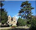
The Farmhouse, Begbroke Science Park
Begbroke Science Park is in modern units centred around this old building.
It is part of Oxford University. http://www.begbroke.ox.ac.uk/
They call this The Farmhouse, although it looks a bit grand for that.
Image: © Des Blenkinsopp
Taken: 23 Oct 2013
0.18 miles
5
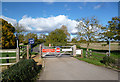
Not This Way
This leads in to Begbroke Science Park but you've got to go round some other way.
Image: © Des Blenkinsopp
Taken: 23 Oct 2013
0.19 miles
6
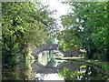
Yarnton Bridge seen from the North.
Image: © Michel Van den Berghe
Taken: 9 Oct 2005
0.20 miles
8
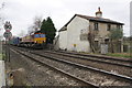
Intermodal train approaches Sandy Lane Crossing
The freight train, hauled by Class 66/0 diesel locomotive number 66135, is seen from the Sandy Lane level crossing. The house is 'Crossing Cottage'.
Image: © Roger Templeman
Taken: 28 Nov 2012
0.24 miles