IMAGES TAKEN NEAR TO
Elsfield, OXFORD, OX3 9UN
Introduction
This page details the photographs taken nearby to OX3 9UN by members of the Geograph project.
The Geograph project started in 2005 with the aim of publishing, organising and preserving representative images for every square kilometre of Great Britain, Ireland and the Isle of Man.

There are currently over 7.5m images from over14,400 individuals and you can help contribute to the project by visiting https://www.geograph.org.uk
Image Map
Images are licensed for reuse under creativecommons.org/licenses/by-sa/2.0
Notes
- Clicking on the map will re-center to the selected point.
- The higher the marker number, the further away the image location is from the centre of the postcode.
Image Listing (3 Images Found)
Images are licensed for reuse under creativecommons.org/licenses/by-sa/2.0
Image
Details
Distance
1
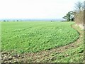
East of Elsfield
The road does a loop around this field, to North and East of Elsfield. It runs the other side of the hedge on the right and then across, below the brow of the hill, the tops of some of the trees in the hedge can just be seen.
Image: © David Luther Thomas
Taken: 2 Feb 2007
0.05 miles
2
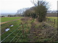
Bridleway by Forest Farm
Bridleway by Forest Farm heading down towards Woodeaton woods
Image: © Shaun Ferguson
Taken: 20 Dec 2008
0.09 miles
3
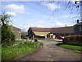
Forest Farm, Elsfield
The most northerly buildings in the village.
Image: © Des Blenkinsopp
Taken: 1 May 2012
0.10 miles