IMAGES TAKEN NEAR TO
Kingston Hill, CHINNOR, OX39 4SF
Introduction
This page details the photographs taken nearby to Kingston Hill, OX39 4SF by members of the Geograph project.
The Geograph project started in 2005 with the aim of publishing, organising and preserving representative images for every square kilometre of Great Britain, Ireland and the Isle of Man.

There are currently over 7.5m images from over14,400 individuals and you can help contribute to the project by visiting https://www.geograph.org.uk
Image Map
Images are licensed for reuse under creativecommons.org/licenses/by-sa/2.0
Notes
- Clicking on the map will re-center to the selected point.
- The higher the marker number, the further away the image location is from the centre of the postcode.
Image Listing (28 Images Found)
Images are licensed for reuse under creativecommons.org/licenses/by-sa/2.0
Image
Details
Distance
1
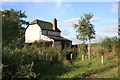
Crossing Cottage, Kingston Blount
That's the name on the gate of this isolated house by where an old railway line used to cross a minor road, so I'm guessing this was where a level crossing keeper would have lived.
This was taken from the Ridgeway, with the rail track shown as going right past the front door where the garden is now.
Image: © Des Blenkinsopp
Taken: 19 Sep 2013
0.00 miles
2
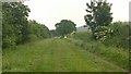
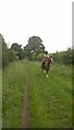
The Ridgeway
Straight wide path with runner.
Image: © James Emmans
Taken: 14 Jun 2015
0.01 miles
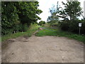
3
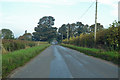
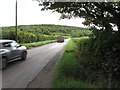
Road towards Kingston Blount
The former branch railway from Princes Risborough to Watlington crossed the road on the level just beyond the large tree.
Image: © Robin Webster
Taken: 20 Oct 2018
0.01 miles
4
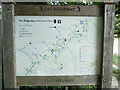
The Ridgeway National Trail Board, Kingston Hill
This board is located off Kingston Hill OX39 4SF and shows a map of The Ridgeway from
Ivinghoe Beacon in the north east to Watlington in the south west. The Icknield Way and the
Swan's Way also pass through this location.
Image: © David Hillas
Taken: 28 Jul 2024
0.02 miles
5
Icknield Way and Ridgeway at Kingston Hill
The gate and sign show that this is a bridleway, not for motor vehicles.
Image: © David Hawgood
Taken: 25 Sep 2015
0.03 miles
7
Ridgeway bridleway crosses Kingston Hill road
There are "Bridleway only" signs at the junction, and a gate to prevent unauthorised motor vehicles.
Image: © David Hawgood
Taken: 25 Sep 2015
0.05 miles
9
Kingston Hill and Kingston Wood
The road climbs Kingston Hill towards Stokenchurch. Photo from junction with the Ridgeway - which here is along the Icknield Way, not on the wooded scarp.
Image: © David Hawgood
Taken: 25 Sep 2015
0.07 miles
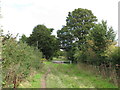
10
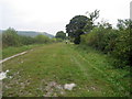
Ridgeway near Kingston Blount
Taken by the minor road from Kingston Blount, the Ridgeway (Upper Icknield Way) is a much more pleasant grassy track from the quagmire it has been reduced to near Chinnor.
Image: © Chris Heaton
Taken: 1 Oct 2007
0.08 miles