IMAGES TAKEN NEAR TO
Oxford Road, OXFORD, OX33 1RT
Introduction
This page details the photographs taken nearby to Oxford Road, OX33 1RT by members of the Geograph project.
The Geograph project started in 2005 with the aim of publishing, organising and preserving representative images for every square kilometre of Great Britain, Ireland and the Isle of Man.

There are currently over 7.5m images from over14,400 individuals and you can help contribute to the project by visiting https://www.geograph.org.uk
Image Map
Images are licensed for reuse under creativecommons.org/licenses/by-sa/2.0
Notes
- Clicking on the map will re-center to the selected point.
- The higher the marker number, the further away the image location is from the centre of the postcode.
Image Listing (59 Images Found)
Images are licensed for reuse under creativecommons.org/licenses/by-sa/2.0
Image
Details
Distance
1
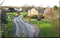
Horspath: Cuddesdon Road
Viewed looking W from the top of Image Geoff's Image is the leftmost visible building. The small building on the green is the bus shelter for travellers bound for Oxford.
Image: © Nigel Cox
Taken: 16 Jan 2008
0.02 miles
2
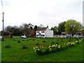
Cottage, village green and daffodils, Horspath
Image: © Bikeboy
Taken: 7 Apr 2014
0.04 miles
3
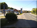
Horspath Garage
The view of the Gulf Garage on Oxford Road in Horspath Village.
Image: © Gordon Griffiths
Taken: 1 Jun 2013
0.04 miles
4
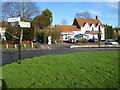
Horspath: The Chequers Inn
The Chequers Inn is located on The Green, with the attached Taste of India restaurant.
A search of the 1881 Census reveals the following occupants:
Name:Relation to Head of Household:Marital Status:Gender:Age:Birthplace: Occupation
Tom ROWLAND Head Married Male 33 Sparsholt, Berkshire Publican
Elizabeth ROWLAND Wife Married Female 34 Hagbourne, Berkshire
The signpost states 2¾ miles to both Wheatley and Cuddesdon and that this road also forms National Cycle Network Route 57, which runs from Cricklade in Wiltshire to Welwyn Garden City in Hertfordshire via Oxford.
Image: © Nigel Cox
Taken: 16 Jan 2008
0.04 miles
5
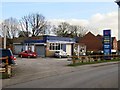
Horspath Service Station on Oxford Road
Image: © Steve Daniels
Taken: 20 Mar 2018
0.04 miles
6
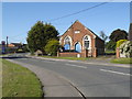
Methodist Chapel
The view of the Chapel off the green in Oxford Road in Horspath Village.
Image: © Gordon Griffiths
Taken: 1 Jun 2013
0.04 miles
7
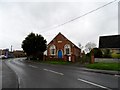
Methodist Chapel, Horspath
The stone on the front says that it was built in 1909, but other sources claim a Methodist chapel was built in Horspath in 1871. Perhaps this one replaced an earlier structure.
Image: © Bikeboy
Taken: 7 Apr 2014
0.05 miles
8
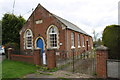
Methodist Chapel, Oxford Road
There is an OS benchmark Image on the side of the chapel at the near corner left of the grey downpipe. The inscribed stone above the blue door indicates the chapel was built in 1909.
Image: © Roger Templeman
Taken: 10 Apr 2014
0.05 miles
9
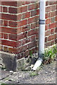
Benchmark on Wesleyan Chapel
Ordnance Survey cut mark benchmark described on the Bench Mark Database at http://www.bench-marks.org.uk/bm36617
Image: © Roger Templeman
Taken: 10 Apr 2014
0.05 miles
10
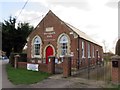
The Horspath Hub on Oxford Road
Hub is in the former Methodist Chapel.
Image: © Steve Daniels
Taken: 20 Mar 2018
0.05 miles