IMAGES TAKEN NEAR TO
Shotover Estate, OXFORD, OX33 1QS
Introduction
This page details the photographs taken nearby to Shotover Estate, OX33 1QS by members of the Geograph project.
The Geograph project started in 2005 with the aim of publishing, organising and preserving representative images for every square kilometre of Great Britain, Ireland and the Isle of Man.

There are currently over 7.5m images from over14,400 individuals and you can help contribute to the project by visiting https://www.geograph.org.uk
Image Map
Images are licensed for reuse under creativecommons.org/licenses/by-sa/2.0
Notes
- Clicking on the map will re-center to the selected point.
- The higher the marker number, the further away the image location is from the centre of the postcode.
Image Listing (13 Images Found)
Images are licensed for reuse under creativecommons.org/licenses/by-sa/2.0
Image
Details
Distance
1

Aerial View of Shotover House
Taken from paramotor. "Shotover House and garden were begun in about 1714 for James Tyrrell of Oakley. Tyrell died in 1718 and the house was completed by his son, General James Tyrell. There is no known record of the name of the architect. In 1855 the architect Joshua Sims added two wings in the same style of the original part of the house." (see http://en.wikipedia.org/wiki/Shotover#Shotover_House) The Obelisk can just be seen behind the main house.
Image: © Dave Price
Taken: 2 Sep 2014
0.01 miles
2
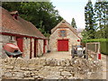
Shotover Stables
Shotover Stable beneath the clock tower by Shotover house
Image: © Shaun Ferguson
Taken: 28 Dec 2008
0.11 miles
3
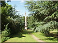
Obelisk, garden of Shotover House
The obelisk was designed by William Kent in the 1730s when he laid out the gardens west of Shotover House. The Oxford Inscriptions website recorded the story that it marks the place where Elizabeth 1st took leave of Oxford in 1592 on her last visit.
Image: © David Hawgood
Taken: 22 Jun 2006
0.14 miles
4

Temple, Shotover Estate
The same place as Image some six years on. The doorways have been blocked up and the statues have gone from the niches.
Image: © Des Blenkinsopp
Taken: 5 Feb 2013
0.18 miles
6
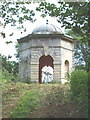
Temple at Shotover House
The temple was designed by William Kent when laying out this area of the gardens in the 1730s.
Image: © David Hawgood
Taken: 22 Jun 2006
0.19 miles
7
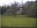
Outbuildings of Shotover House
Shotover House is in the background
Image: © David Hawgood
Taken: 22 Jun 2006
0.20 miles
8
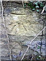
Benchmark on wall on south side of A40.
Ordnance Survey cut mark benchmark described on the Bench Mark Database at http://www.bench-marks.org.uk/bm36596
Image: © Roger Templeman
Taken: 27 Jan 2011
0.20 miles