IMAGES TAKEN NEAR TO
Lower Road, WITNEY, OX29 8LW
Introduction
This page details the photographs taken nearby to Lower Road, OX29 8LW by members of the Geograph project.
The Geograph project started in 2005 with the aim of publishing, organising and preserving representative images for every square kilometre of Great Britain, Ireland and the Isle of Man.

There are currently over 7.5m images from over14,400 individuals and you can help contribute to the project by visiting https://www.geograph.org.uk
Image Map
Images are licensed for reuse under creativecommons.org/licenses/by-sa/2.0
Notes
- Clicking on the map will re-center to the selected point.
- The higher the marker number, the further away the image location is from the centre of the postcode.
Image Listing (13 Images Found)
Images are licensed for reuse under creativecommons.org/licenses/by-sa/2.0
Image
Details
Distance
1
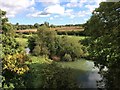
View from a Didcot-Worcester train - Crossing the River Evenlode
Image: © Nigel Thompson
Taken: 22 Sep 2017
0.15 miles
4
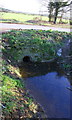
Culvert for stream under road near Mill Farm
A footpath runs along the side of the stream to Pinsley Wood
Image: © Roger Templeman
Taken: 15 Feb 2016
0.19 miles
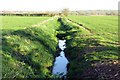
5
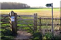
Gate on the footpath
The footpath runs past Pinsley Wood to Long Hanborough.
Image: © Steve Daniels
Taken: 19 Mar 2014
0.20 miles
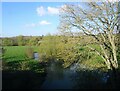
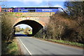
6
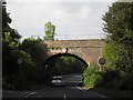
Railway bridge over the road to Bladon
The bridge goes over the minor road running from the A40 at Eynsham to the A4095 between Long Hanborough and Bladon.
Image: © andrew auger
Taken: 8 Jul 2010
0.22 miles
7
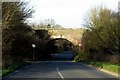
The road runs under the Cotswold Line near Long Hanborough
Image: © Steve Daniels
Taken: 19 Mar 2014
0.22 miles
9
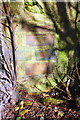
Benchmark on railway bridge, Lower Road
Ordnance Survey cut mark benchmark described on the Bench Mark Database at http://www.bench-marks.org.uk/bm73805
Image: © Roger Templeman
Taken: 15 Feb 2016
0.22 miles
10
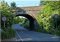
Bridge 70m 195ch OWW, Lower Road
There is an OS benchmark Image on the near end of the right hand side of the bridge arch. A HST led by Class 43 power car number 43160 'Sir Moir Lockhead OBE heads towards Paddington, 70 miles away.
Image: © Roger Templeman
Taken: 15 Feb 2016
0.22 miles