IMAGES TAKEN NEAR TO
The Downs, WITNEY, OX29 7SH
Introduction
This page details the photographs taken nearby to The Downs, OX29 7SH by members of the Geograph project.
The Geograph project started in 2005 with the aim of publishing, organising and preserving representative images for every square kilometre of Great Britain, Ireland and the Isle of Man.

There are currently over 7.5m images from over14,400 individuals and you can help contribute to the project by visiting https://www.geograph.org.uk
Image Map
Images are licensed for reuse under creativecommons.org/licenses/by-sa/2.0
Notes
- Clicking on the map will re-center to the selected point.
- The higher the marker number, the further away the image location is from the centre of the postcode.
Image Listing (15 Images Found)
Images are licensed for reuse under creativecommons.org/licenses/by-sa/2.0
Image
Details
Distance
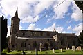
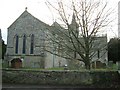
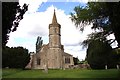
2
St Giles' church, Standlake from the north
Image: © Chris Brown
Taken: 24 Feb 2017
0.22 miles
4
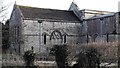
St Giles, Standlake: chancel and north transept
Showing two blocked mediaeval windows, the chancel one with flamboyant tracery.
Image: © Chris Brown
Taken: 24 Feb 2017
0.23 miles
5
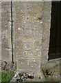
Benchmark and other features
The tower of St Giles church, Standlake, has a fine cutmark; alongside it are what appears to be the mere trace of a circle with a concrete plug near the centre, and above that a sundial of sorts.
See http://www.bench-marks.org.uk/bm39406 for the Benchamrk Database, and Image] for a look up the tower.
Image: © Neil Owen
Taken: 3 Sep 2011
0.23 miles
6
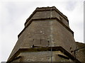
St Giles tower, Standlake
Looking up the tower of the church shows the octagonal design. The church dates back to the late twelfth century, but the tower - with a small spire - was built in the fourteenth. See Image] for a distant view, and Image] for a benchmark.
Image: © Neil Owen
Taken: 3 Sep 2011
0.23 miles
7
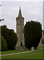
St Giles church tower
Fourteenth century church design has left us with this octagonal tower, topped off with a small spire. See Image] for a pic demonstrating the shape.
Image: © Neil Owen
Taken: 3 Sep 2011
0.23 miles
9
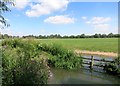
Escaped the quarrying
This riverside field has so far avoided being turned into a lake by the gravel diggers, unlike most of the similar land just north of here.
Image: © Des Blenkinsopp
Taken: 22 Jul 2014
0.23 miles
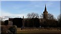
10
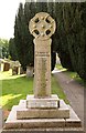
Standlake war memorial
The war memorial is in St Giles' churchyard.
Image: © Steve Daniels
Taken: 13 Jun 2013
0.23 miles