IMAGES TAKEN NEAR TO
Station Road, WITNEY, OX29 4XH
Introduction
This page details the photographs taken nearby to Station Road, OX29 4XH by members of the Geograph project.
The Geograph project started in 2005 with the aim of publishing, organising and preserving representative images for every square kilometre of Great Britain, Ireland and the Isle of Man.

There are currently over 7.5m images from over14,400 individuals and you can help contribute to the project by visiting https://www.geograph.org.uk
Image Map
Images are licensed for reuse under creativecommons.org/licenses/by-sa/2.0
Notes
- Clicking on the map will re-center to the selected point.
- The higher the marker number, the further away the image location is from the centre of the postcode.
Image Listing (96 Images Found)
Images are licensed for reuse under creativecommons.org/licenses/by-sa/2.0
Image
Details
Distance
1
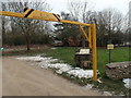
Entrance to Abbey Meadows
Entrance to the Abbey Meadows recreation area and Eynsham footpath number 3.
Image: © Paul Harris
Taken: 9 Feb 2012
0.01 miles
2
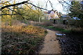
Footpath Near Eynsham
This footpath runs along low lying land just adjacent to the Chil Brook which is just on the right of the picture. Consequently it is very muddy and a large amount of crushed stone has been added to improve the walking surface.
Image: © Nigel Mykura
Taken: 1 Mar 2017
0.01 miles
3
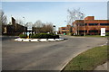
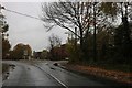
Roundabout at the junction of Station Road and the B4449, Eynsham
Looking west along the route of the former Oxford, Witney and Fairford Railway. There was once a level crossing at this point, with the B4449 coming in (as it still does) from the left and continuing into Eynsham along Station Road to our right. Today, however, the B4449 turns to the east here to follow the trackbed of the closed line (on which we are standing), with Old Station Way, ahead, occupying the site of Eynsham station, which closed in 1962.
Image: © Roger Templeman
Taken: 12 Mar 2011
0.05 miles
5
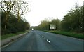
Roundabout on Stanton Harcourt Road, Eynsham
Image: © David Howard
Taken: 9 Nov 2019
0.06 miles
6
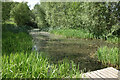
Medieval Fishpond, Eynsham Meadows
The site of Eynsham Abbey is just north of here and in the middle ages the abbots created a series of fish ponds on the estate using water from the nearby Chill Brook.
The area is still wetland and is now a nature reserve.
Image: © Des Blenkinsopp
Taken: 9 Jun 2021
0.06 miles
7
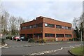
The old HQ
This building used to be the old Oxford Instruments Group PLC before the place was sold off. They now work out of the Tubney site
Image: © Bill Nicholls
Taken: 16 Mar 2021
0.07 miles
8
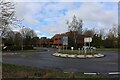
Station Way
Looking over the Stanton Harcourt Roundabout towards Station Way
Image: © Bill Nicholls
Taken: 16 Mar 2021
0.07 miles
9
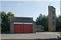
Eynsham fire station
Eynsham fire station, Station Road, Eynsham, Oxfordshire
Image: © Kevin Hale
Taken: 5 Oct 2007
0.09 miles
10
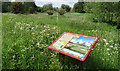
Abbot Adam's Grand Plan
The title on a visitor board in Eynsham Meadows. Now a wetland nature reserve, in medieval times this was in the grounds of Eynsham Abbey, where an abbot called Adam developed the estate and added a series of fish ponds to provide food. This colourful board gives an artists impression of what the place might have looked like.
Image: © Des Blenkinsopp
Taken: 9 Jun 2021
0.09 miles