IMAGES TAKEN NEAR TO
Hollis Close, WITNEY, OX28 3SW
Introduction
This page details the photographs taken nearby to Hollis Close, OX28 3SW by members of the Geograph project.
The Geograph project started in 2005 with the aim of publishing, organising and preserving representative images for every square kilometre of Great Britain, Ireland and the Isle of Man.

There are currently over 7.5m images from over14,400 individuals and you can help contribute to the project by visiting https://www.geograph.org.uk
Image Map (Loading...)


Getting Data...Please wait
Leaflet Map data © OpenStreetMap
Images are licensed for reuse under creativecommons.org/licenses/by-sa/2.0
Notes
- Clicking on the map will re-center to the selected point.
- The higher the marker number, the further away the image location is from the centre of the postcode.
Image Listing (28 Images Found)
Images are licensed for reuse under creativecommons.org/licenses/by-sa/2.0
Image
Details
Distance
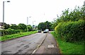
2
Cycleway & footpath from Cogges Hill Road to Stanton Harcourt Road, Cogges, Witney, Oxon
Linking two of the main roads on the Cogges Estate, a modern residential estate on the eastern side of Witney.
Image: © P L Chadwick
Taken: 27 May 2017
0.07 miles
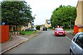
3
Cogges Hill Road, Cogges, Witney, Oxon
One of the main roads in the modern Cogges Estate, which is one of Witney's most popular residential areas. The road on the left is Oxlease.
Image: © P L Chadwick
Taken: 27 May 2017
0.07 miles
4
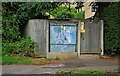
Electricity substation, Cogges Hill Road, Cogges, Witney, Oxon
Electricity substation serving the Cogges Estate, a modern residential area on the eastern side of the town.
Image: © P L Chadwick
Taken: 27 May 2017
0.08 miles
5

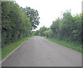
Mud Lane, Cogges, Witney, Oxon
Cycleway and footpath which in this direction is heading towards the town centre. There is a cyclist in the very far distance.
Image: © P L Chadwick
Taken: 27 May 2017
0.09 miles
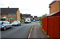
6
Cogges Hill Road, Cogges, Witney, Oxon
One of the main roads on the residential Cogges Estate. In this direction the road terminates at the Blake Church of England Primary School and the Cogges Museum car park.
Image: © P L Chadwick
Taken: 27 May 2017
0.09 miles
7
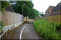
Cycleway & footpath to Blakes Avenue, Cogges, Witney, Oxon
Blakes Avenue is on the other side of the bollards, which can be seen in the distance.
Image: © P L Chadwick
Taken: 27 May 2017
0.12 miles
8
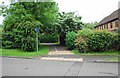
Blakes Avenue, Cogges, Witney, Oxon
In this direction this road of modern housing eventually comes out on Cogges Hill Road. The combined cycleway and public footpath on the left provides a route to Witney's town centre.
Image
Image: © P L Chadwick
Taken: 27 May 2017
0.13 miles
9
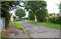
Blakes Avenue, Cogges, Witney, Oxon
In this direction the road leads to Eton Close, from which Stanton Harcourt Road can be reached. The Cogges Estate, of which Blakes Avenue is part, contains modern housing and is on the edge of the town.
Image
Image: © P L Chadwick
Taken: 27 May 2017
0.13 miles
10
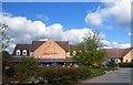
Tesco's in Cogges
Apart from the Church, Manor House and Farm Museum most of Cogges is a modern suburb, with a Tesco's.
Image: © Des Blenkinsopp
Taken: 15 Apr 2012
0.14 miles