IMAGES TAKEN NEAR TO
Blakes Avenue, WITNEY, OX28 3SU
Introduction
This page details the photographs taken nearby to Blakes Avenue, OX28 3SU by members of the Geograph project.
The Geograph project started in 2005 with the aim of publishing, organising and preserving representative images for every square kilometre of Great Britain, Ireland and the Isle of Man.

There are currently over 7.5m images from over14,400 individuals and you can help contribute to the project by visiting https://www.geograph.org.uk
Image Map (Loading...)


Getting Data...Please wait
Leaflet Map data © OpenStreetMap
Images are licensed for reuse under creativecommons.org/licenses/by-sa/2.0
Notes
- Clicking on the map will re-center to the selected point.
- The higher the marker number, the further away the image location is from the centre of the postcode.
Image Listing (25 Images Found)
Images are licensed for reuse under creativecommons.org/licenses/by-sa/2.0
Image
Details
Distance
1
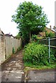
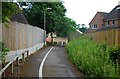
Public footpath from Blakes Avenue, Cogges, Witney, Oxon
The footpath gives access to nearby fields.
Image: © P L Chadwick
Taken: 27 May 2017
0.02 miles
2
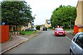
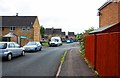
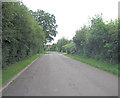
Blakes Avenue, Cogges, Witney, Oxon
In this direction this road of modern housing eventually comes out on Cogges Hill Road. The combined cycleway and public footpath on the left provides a route to Witney's town centre.
Image
Image: © P L Chadwick
Taken: 27 May 2017
0.03 miles
3
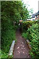
Public footpath to Blakes Avenue, Cogges, Witney, Oxon
This public footpath connects nearby fields to Blakes Avenue, which is on the edge of the built-up area. The town centre can be reached by other public footpaths which link to Blakes Avenue. In the foreground is a footbridge over a shallow stream.
Image: © P L Chadwick
Taken: 27 May 2017
0.03 miles
4
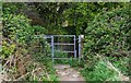
Kissing gate on public footpath, Cogges, Witney, Oxon
This kissing gate is on a public footpath to Blakes Avenue, a residential road.
Image: © P L Chadwick
Taken: 8 May 2017
0.03 miles
5
Cycleway & footpath to Blakes Avenue, Cogges, Witney, Oxon
Blakes Avenue is on the other side of the bollards, which can be seen in the distance.
Image: © P L Chadwick
Taken: 27 May 2017
0.04 miles
6
Blakes Avenue, Cogges, Witney, Oxon
In this direction the road leads to Eton Close, from which Stanton Harcourt Road can be reached. The Cogges Estate, of which Blakes Avenue is part, contains modern housing and is on the edge of the town.
Image
Image: © P L Chadwick
Taken: 27 May 2017
0.04 miles
7
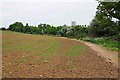
Public footpath along the edge of a field, Cogges, Witney, Oxon
The public footpath goes along a short section of the edge of this field and then turns right into the adjacent field. There is a path continuing further along the edge of the field, although this is not marked as a public footpath on the O.S. map. However it seems to be used by the public.
Image: © P L Chadwick
Taken: 8 May 2017
0.08 miles
8
Public footpath into next field, Cogges, Witney, Oxon
The public footpath from Blakes Avenue continues into the next field.
Image: © P L Chadwick
Taken: 8 May 2017
0.10 miles
10
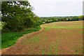
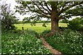
Footpath along edge of field, near Cogges, Witney, Oxon
There is a footpath along the edge of this field although it isn't shown as a public footpath on the OS map. Later it joins a public footpath which comes into this field from an adjacent field, and then continues to Blakes Avenue, a residential road in Cogges.
Image: © P L Chadwick
Taken: 8 May 2017
0.14 miles