IMAGES TAKEN NEAR TO
Jackson Road, OXFORD, OX2 7TP
Introduction
This page details the photographs taken nearby to Jackson Road, OX2 7TP by members of the Geograph project.
The Geograph project started in 2005 with the aim of publishing, organising and preserving representative images for every square kilometre of Great Britain, Ireland and the Isle of Man.

There are currently over 7.5m images from over14,400 individuals and you can help contribute to the project by visiting https://www.geograph.org.uk
Image Map
Images are licensed for reuse under creativecommons.org/licenses/by-sa/2.0
Notes
- Clicking on the map will re-center to the selected point.
- The higher the marker number, the further away the image location is from the centre of the postcode.
Image Listing (56 Images Found)
Images are licensed for reuse under creativecommons.org/licenses/by-sa/2.0
Image
Details
Distance
1
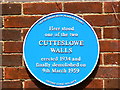
Blue plaque, Aldrich Road, Oxford
Generally, to get a blue plaque affixed to a house, the subject has to be (a) a person, (b) famous and (c) dead. In this case the main protagonists are people and aren't particularly famous although they are almost certainly dead; they certainly don't warrant a blue plaque. It is what they got up to that does. Read on to find out why.
Note. This image has a detailed ‘shared description’ which you won’t see by viewing this image on a slideshow. To read it click on the image.
Image: © Brian Robert Marshall
Taken: 28 Jul 2010
0.05 miles
2
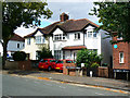
Houses in Wentworth Road, Oxford
The well-maintained houses in the centre are typical of between the wars middle-class residences built in the thousands in the 1930s up and down the country. In most respects they are no different from any of the others that can be found. However, they lie at the root of a quite fascinating example of how class distinctions can create conflict and, in this case, a rare study in enforced segregation.
Note. This image has a detailed ‘shared description’ which you won’t see by viewing this image on a slideshow. To read it click on the image.
Image: © Brian Robert Marshall
Taken: 28 Jul 2010
0.06 miles
3
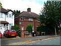
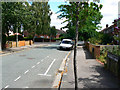
Junction of Wentworth Road and Aldrich Road, Oxford
I don't often replicate scenes that can be seen just as well on 'Streetview' but there are occasions where it is worth the effort. There is a reason why what appears to be the same road has two names and why the architectural style of the white house on left differs from the redbrick one on the right.
Note. This image has a detailed ‘shared description’ which you won’t see by viewing this image on a slideshow. To read it click on the image.
Image: © Brian Robert Marshall
Taken: 28 Jul 2010
0.06 miles
4
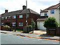
Houses in Aldrich Road, Oxford
This is on the face of it an unremarkable view of a typical pre-war municipal housing development; a view that could be replicated just about anywhere in southern England. However, if I had been standing in the same spot at any time between late 1934 and early 1959 my view would have been blocked by a mini version of the Berlin Wall. The reasons for this are all to do the fear of people who are 'not quite our class darling'.
Note. This image has a detailed ‘shared description’ which you won’t see by viewing this image on a slideshow. To read it click on the image.
Image: © Brian Robert Marshall
Taken: 28 Jul 2010
0.06 miles
5
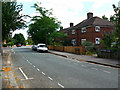
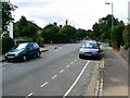
Looking east from Wentworth Road into Aldrich Road, Oxford
At virtually any time between December 1934 and 8th March 1959 this view wouldn't have been possible.
Note. This image has a detailed ‘shared description’ which you won’t see by viewing this image on a slideshow. To read it click on the image.
Image: © Brian Robert Marshall
Taken: 28 Jul 2010
0.06 miles
6
Looking east along Wolsey Road, Oxford
Another routine shot of a road in a municipal housing estate. It looks like a pleasant place to live and the residents in the main are, I'm sure, perfectly nice law-abiding citizens who like to be good neighbours. Back in the early 1930s though the tenants of the Oxford Corporation were deemed to be so evil that they were physically stopped from entering a nearby private housing estate - for twenty-five years.
Note. This image has a detailed ‘shared description’ which you won’t see by viewing this image on a slideshow. To read it click on the image.
Image: © Brian Robert Marshall
Taken: 28 Jul 2010
0.06 miles
7
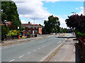
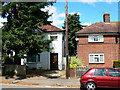
Wolsey and Carlton Roads, Oxford
The white-painted house is 32 Carlton Road. Its neighbour on the other side of the lamp-post is 61 Wolsey Road. They don't look a great deal different and the accommodation they provide is probably broadly similar, three bedrooms, bathroom, kitchen and one or two reception rooms. They are even about the same age having been built in 1933 or 34. However the then occupiers of the redbrick house were deemed to be such a threat to the wellbeing of the occupiers of the white house that a wall was built across the road between the two to keep them separate. This curious example of segregation in the United Kingdom survived more or less intact for the entire period from 1934 until 1959 (a car did crash into it in 1936 but the wall was quickly repaired).
Note. This image has a detailed ‘shared description’ which you won’t see by viewing this image on a slideshow. To read it click on the image.
Image: © Brian Robert Marshall
Taken: 28 Jul 2010
0.07 miles
8
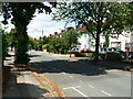
Looking west along Wentworth Road, Oxford
This view won't have changed a great deal since around 1934 when Wentworth Road was completed. The cars won't have been German-built VWs and Fords, more likely they would have been Morris Oxfords made down the road in Cowley. It would have been a different story looking in the opposite direction http://www.geograph.org.uk/photo/1984885
Note. This image has a detailed ‘shared description’ which you won’t see by viewing this image on a slideshow. To read it click on the image.
Image: © Brian Robert Marshall
Taken: 28 Jul 2010
0.08 miles
9
Carlton and Wolsey Roads, Oxford
Why bother with this? Streetview do it just as well. In most cases I wouldn't have. However, there is a reason and it's to do with class distinctions. The white house on the left is 59 Carlton Road. Its neighbour on the right is 94 Wolsey Road. Carlton Road was developed by a private company; Wolsey Road by the City of Oxford. The street names are different because the private company didn't want the reputation of its estate sullied by association with the council estate. The developers felt so strongly about this that they built a wall between the two houses extending across the road towards the viewpoint. Hard to credit but it stayed there for the great majority of the time between late 1934 and 9th March 1959. To find out why read on.
Note. This image has a detailed ‘shared description’ which you won’t see by viewing this image on a slideshow. To read it click on the image.
Image: © Brian Robert Marshall
Taken: 28 Jul 2010
0.08 miles
10
Looking west along Carlton Road, Oxford
Carlton Road is a typical 1930s private housing development no different from many others. It looks much like this one http://www.geograph.org.uk/photo/1985413 However its occupiers were deemed to be under threat from the folk living in the neighbouring estate to the extent that a wall had to be put up to keep them out. Why? Because the occupiers of the latter estate were council tenants.
Note. This image has a detailed ‘shared description’ which you won’t see by viewing this image on a slideshow. To read it click on the image.
Image: © Brian Robert Marshall
Taken: 28 Jul 2010
0.09 miles