IMAGES TAKEN NEAR TO
Stratton Audley, BICESTER, OX27 9AN
Introduction
This page details the photographs taken nearby to OX27 9AN by members of the Geograph project.
The Geograph project started in 2005 with the aim of publishing, organising and preserving representative images for every square kilometre of Great Britain, Ireland and the Isle of Man.

There are currently over 7.5m images from over14,400 individuals and you can help contribute to the project by visiting https://www.geograph.org.uk
Image Map
Images are licensed for reuse under creativecommons.org/licenses/by-sa/2.0
Notes
- Clicking on the map will re-center to the selected point.
- The higher the marker number, the further away the image location is from the centre of the postcode.
Image Listing (9 Images Found)
Images are licensed for reuse under creativecommons.org/licenses/by-sa/2.0
Image
Details
Distance
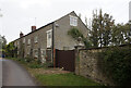
3
The Old Mill
By the lane from Stratton Audley to Chetwode.
Image: © Jonathan Billinger
Taken: 12 Apr 2007
0.04 miles
4
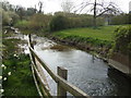
The mill stream
At the old mill near Stratton Audley.
Image: © Jonathan Billinger
Taken: 12 Apr 2007
0.04 miles
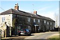
5
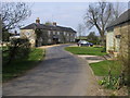
The Old Mill
The road curves past The Old Mill
Image: © Shaun Ferguson
Taken: 10 Apr 2010
0.05 miles
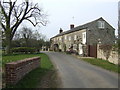
6
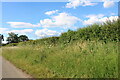
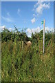
Verge by Mill Road near Newton Morrell
Image: © David Howard
Taken: 13 Jun 2020
0.16 miles
9
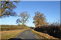
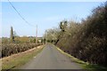
Lane towards Tingewick
This route or its trace parallels the Roman Bicester - Towcester road (partly now the A4421) at a remove of about 1 km for around 10 km, from Stratton Audley to the River Ouse north of Tingewick. This view is where the otherwise fairly straight route has a significant modern distortion across a stream and its low-lying land. The perhaps earlier straighter crossing is hinted at by a footpath and parish boundary.
Image: © Robin Webster
Taken: 4 Dec 2016
0.22 miles