IMAGES TAKEN NEAR TO
Chesterton, BICESTER, OX26 1UL
Introduction
This page details the photographs taken nearby to OX26 1UL by members of the Geograph project.
The Geograph project started in 2005 with the aim of publishing, organising and preserving representative images for every square kilometre of Great Britain, Ireland and the Isle of Man.

There are currently over 7.5m images from over14,400 individuals and you can help contribute to the project by visiting https://www.geograph.org.uk
Image Map
Images are licensed for reuse under creativecommons.org/licenses/by-sa/2.0
Notes
- Clicking on the map will re-center to the selected point.
- The higher the marker number, the further away the image location is from the centre of the postcode.
Image Listing (15 Images Found)
Images are licensed for reuse under creativecommons.org/licenses/by-sa/2.0
Image
Details
Distance
1
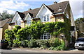
Top Green Cottage, Chesterton
Presumably by the top green, which is very small.
Image: © Robin Webster
Taken: 22 Aug 2020
0.03 miles
2
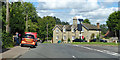
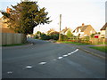
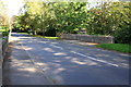
A4095 Junction at Chesterton
A view of the main junction in the village of Chesterton, on the A4095. To the right, the road leads past Bignell Park to Bicester, while to the left it winds and leads to the B430 and also Kirtlington. Shot was taken stood on an original and interesting 'village green'.
Image: © Kurt C
Taken: 28 Jul 2007
0.03 miles
3
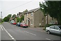
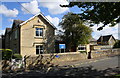
Stone Cottage, Bignell View
There is an OS benchmark Image on the left hand corner of the house, by the parked car
Image: © Roger Templeman
Taken: 23 Sep 2016
0.03 miles
4
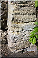
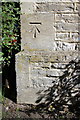
Weathered benchmark on 'Stone Cottage'
Ordnance Survey cut mark benchmark described on the Bench Mark Database at http://www.bench-marks.org.uk/bm79289
Image: © Roger Templeman
Taken: 23 Sep 2016
0.03 miles
6
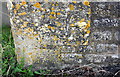
Benchmark on Chesterton CE Primary School
Ordnance Survey cut mark benchmark described on the Bench Mark Database at http://www.bench-marks.org.uk/bm79261
Image: © Roger Templeman
Taken: 23 Sep 2016
0.09 miles
7
Chesterton CE Primary School, Alchester Road
There is an OS benchmark Image on the near corner, road face, of the school
Image: © Roger Templeman
Taken: 23 Sep 2016
0.09 miles
8
Benchmark on bridge over Gagle Brook
Ordnance Survey cut mark benchmark described on the Bench Mark Database at http://www.bench-marks.org.uk/bm79288
Image: © Roger Templeman
Taken: 23 Sep 2016
0.09 miles
9
Bridge taking A4095 over Gagle Brook
There is an OS benchmark Image on the far end, road face, of the right hand parapet
Image: © Roger Templeman
Taken: 23 Sep 2016
0.09 miles
10
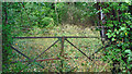
Gates to Chesterton Pumping Station
In the mid 20th century the former local authority for this area, Ploughley Rural District Council, had a policy of building small developments of new housing in a number of its villages. Where there wasn't an adequate water supply, the council put in small pumping stations to provide water from a borehole. In 1974 with the setting up of the national Water Authorities, these small stations passed into the care of the Thames Water Authority who never wanted them and let them go derelict.
Some of the boreholes were subsequently used by the National Rivers Authority / Environment Agency for water level monitoring, as was this one until the site was sold off.
The map still shows the original site boundaries although the whole place has merged into the surrounding wood. Only the original municipal gates are still here in the undergrowth.
Image: © Des Blenkinsopp
Taken: 15 Jun 2020
0.12 miles