IMAGES TAKEN NEAR TO
Duns Tew, BICESTER, OX25 6JJ
Introduction
This page details the photographs taken nearby to OX25 6JJ by members of the Geograph project.
The Geograph project started in 2005 with the aim of publishing, organising and preserving representative images for every square kilometre of Great Britain, Ireland and the Isle of Man.

There are currently over 7.5m images from over14,400 individuals and you can help contribute to the project by visiting https://www.geograph.org.uk
Image Map
Images are licensed for reuse under creativecommons.org/licenses/by-sa/2.0
Notes
- Clicking on the map will re-center to the selected point.
- The higher the marker number, the further away the image location is from the centre of the postcode.
Image Listing (4 Images Found)
Images are licensed for reuse under creativecommons.org/licenses/by-sa/2.0
Image
Details
Distance
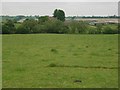
2
Hill Farm, from Plumdon Lane
Duns Tew can be seen on the hill beyond.
SP4529 is all private land with no footpaths, so it's difficult to get a closer view.
Image: © Duncan Lilly
Taken: 1 Jun 2007
0.06 miles
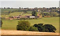
3
Field by Hill Farm
Field above Duns Tew by Hill Farm
Image: © Shaun Ferguson
Taken: 26 Aug 2021
0.09 miles
4
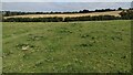
Path heading towards Oxford Road
Path heads through the hedge going towards Oxford Road
Image: © Shaun Ferguson
Taken: 26 Aug 2021
0.20 miles