IMAGES TAKEN NEAR TO
South Side, BICESTER, OX25 4RU
Introduction
This page details the photographs taken nearby to South Side, OX25 4RU by members of the Geograph project.
The Geograph project started in 2005 with the aim of publishing, organising and preserving representative images for every square kilometre of Great Britain, Ireland and the Isle of Man.

There are currently over 7.5m images from over14,400 individuals and you can help contribute to the project by visiting https://www.geograph.org.uk
Image Map
Images are licensed for reuse under creativecommons.org/licenses/by-sa/2.0
Notes
- Clicking on the map will re-center to the selected point.
- The higher the marker number, the further away the image location is from the centre of the postcode.
Image Listing (130 Images Found)
Images are licensed for reuse under creativecommons.org/licenses/by-sa/2.0
Image
Details
Distance
2
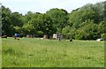
Brown sheep and hen-houses, Steeple Aston
Using telephoto over a wall produces surprises sometimes, in this case a row of what look like wheely bins for recycling in the field.
Image: © Humphrey Bolton
Taken: 25 Jun 2011
0.03 miles
3
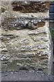
Benchmark on 'Radley Cottage'
Ordnance Survey cut mark benchmark described on the Bench Mark Database at http://www.bench-marks.org.uk/bm75075
Image: © Roger Templeman
Taken: 22 Apr 2016
0.06 miles
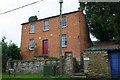
4
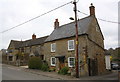
'Radley Cottage' and 'Greenacre', South Side
There is an OS benchmark Image on the right hand side of 'Radley Cottage' (the right hand house) at its rear corner
Image: © Roger Templeman
Taken: 22 Apr 2016
0.07 miles
6

Footpath in Steeple Aston
Two boys stroll along the path that connects South Side (where it is called Stall Close) to North Side (where it is called The Tchure).
Image: © Stephen McKay
Taken: 20 May 2007
0.08 miles
7
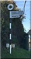
Old Direction Sign - Signpost by South Side, Steeple Aston
Annulus finial - 2 arms; Oxford CC halo by the UC road, in parish of Steeple Aston (Cherwell District), South Side, opposite Paines Hill, on verge.
To be surveyed
Milestone Society National ID: OX_SP4725.
Image: © Milestone Society
Taken: Unknown
0.09 miles
9
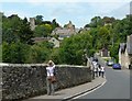
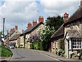
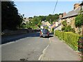
A popular view in Steeple Aston
I took another photograph a minute later, with the people disappearing round the bend in the road. However I could not resist submitting this one.
Image: © Humphrey Bolton
Taken: 25 Jun 2011
0.09 miles
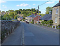
10
Paines Hill
Paines Hill in the village of Steeple Aston.
Image: © Philip Halling
Taken: 6 Sep 2021
0.10 miles