IMAGES TAKEN NEAR TO
Wendlebury, BICESTER, OX25 2NS
Introduction
This page details the photographs taken nearby to OX25 2NS by members of the Geograph project.
The Geograph project started in 2005 with the aim of publishing, organising and preserving representative images for every square kilometre of Great Britain, Ireland and the Isle of Man.

There are currently over 7.5m images from over14,400 individuals and you can help contribute to the project by visiting https://www.geograph.org.uk
Image Map
Images are licensed for reuse under creativecommons.org/licenses/by-sa/2.0
Notes
- Clicking on the map will re-center to the selected point.
- The higher the marker number, the further away the image location is from the centre of the postcode.
Image Listing (8 Images Found)
Images are licensed for reuse under creativecommons.org/licenses/by-sa/2.0
Image
Details
Distance
2
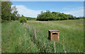
Bin in the Grass
All of a sudden, middle of nowhere, a nice new bin. I think nearby Merton Grounds is home to a few businesses. Perhaps the staff come out here at lunch time. Or maybe they have events in the field. Or something. Who knows. Time to move on.
Image: © Des Blenkinsopp
Taken: 18 May 2020
0.09 miles
3
Footpath by Merton Grounds
Footpath to Langford Lane by Merton Grounds
Image: © Shaun Ferguson
Taken: 29 Dec 2011
0.11 miles
4
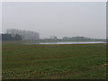
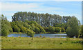
Lake by Merton Grounds
The lake is not shown on the OS maps yet. The buildings of Merton Grounds are in the mist beyond it.
Image: © David Hawgood
Taken: 27 Mar 2007
0.11 miles
5
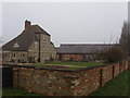
Merton Grounds farmhouse
An unusual shape with three stories, but looking as if bits have been added on.
Image: © David Hawgood
Taken: 27 Mar 2007
0.15 miles
6
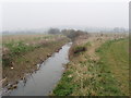
Drainage ditch by Langford Lane
This is just north of Merton Grounds farm. This is a flat area just a couple of metres above the nearby River Ray, and the streams are kept dredged for drainage. There is some pumped drainage of the farmed area.
Image: © David Hawgood
Taken: 27 Mar 2007
0.20 miles
7
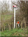
Gas pipeline marker
The markers are designed to be visible from the air.
Image: © David Hawgood
Taken: 27 Mar 2007
0.22 miles