IMAGES TAKEN NEAR TO
Botley Road, OXFORD, OX2 0BL
Introduction
This page details the photographs taken nearby to Botley Road, OX2 0BL by members of the Geograph project.
The Geograph project started in 2005 with the aim of publishing, organising and preserving representative images for every square kilometre of Great Britain, Ireland and the Isle of Man.

There are currently over 7.5m images from over14,400 individuals and you can help contribute to the project by visiting https://www.geograph.org.uk
Image Map
Images are licensed for reuse under creativecommons.org/licenses/by-sa/2.0
Notes
- Clicking on the map will re-center to the selected point.
- The higher the marker number, the further away the image location is from the centre of the postcode.
Image Listing (618 Images Found)
Images are licensed for reuse under creativecommons.org/licenses/by-sa/2.0
Image
Details
Distance
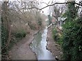
1
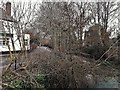
Thames channel and St Frideswide, from Osney Town bridge
Osney Island and West Street with the Hollybush pub are on the left bank; St Frideswide on the right. In fact the land on the right is also islanded, by the channels of the Bulstake Stream.
Image: © Chris Brown
Taken: 24 Mar 2018
0.01 miles
2
St Frideswide, Osney
Seen from West Street on Osney Island, across the western channel of the main Thames stream.
Image: © Chris Brown
Taken: 24 Mar 2018
0.01 miles
3
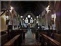
St Frideswide, Botley Road, Oxford
View west along the unaisled nave.
Image: © Chris Brown
Taken: 8 Sep 2018
0.01 miles
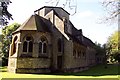
4
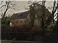
St Frideswide, Osney, Oxford: south side
"Typical [S S] Teulon in its ruthlessness", wrote Pevsner. The south transept shown here includes a vestry blocked from the crossing inside the church by the organ. From this side the squat tower, which never got the spire intended for it, is further obscured by the round chimney turret.
Image: © Chris Brown
Taken: 15 Sep 2017
0.02 miles
5
Link to the rectory
Never seen one of these before, I presume it's a linking corridor to the rectory so the rector does not have to go out in the elements.
Image: © Bill Nicholls
Taken: 30 Dec 2008
0.02 miles
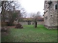
6
Osney Ditch
Flows off Bulstake Stream and links back up with the Thames. It's what makes Osney an Island and causes the bad floods it has.
Image: © Bill Nicholls
Taken: 30 Dec 2008
0.02 miles
7
St Frideswide's Church on Botley Road
Image: © Steve Daniels
Taken: 22 Sep 2012
0.02 miles
8
St Frideswide Church - Botley Road
Image: © Betty Longbottom
Taken: 11 Aug 2013
0.02 miles
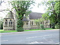
9
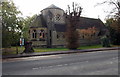
St Frideswide?s Church, New Osney, Oxford
Viewed across the A420 Botley Road. The Anglican church's website states that the building was designed by Samuel Sanders Teulon of Westminster and built by the local firm of Honour & Castle.
It was consecrated and opened for public worship on April 10th 1872. Frideswide (c650-c727),
an English princess and abbess, is the patron saint of the city of Oxford and of Oxford University.
Image: © Jaggery
Taken: 19 Oct 2014
0.02 miles
10

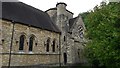
St Frideswide, Botley Road, Oxford
The brick walls of the interior of St Frideswide's have been painted over: a pity, since the architect, S S Teulon was a master of polychromy in brick or stone. This roof vault in the low crossing tower is the only exposed brickwork inside the church and suggests that the patterning under the paint would be worth seeing, although the colour scheme is fairly muted.
Image: © Chris Brown
Taken: 8 Sep 2018
0.02 miles