IMAGES TAKEN NEAR TO
D'Oily Close, BANBURY, OX15 5TP
Introduction
This page details the photographs taken nearby to D'Oily Close, OX15 5TP by members of the Geograph project.
The Geograph project started in 2005 with the aim of publishing, organising and preserving representative images for every square kilometre of Great Britain, Ireland and the Isle of Man.

There are currently over 7.5m images from over14,400 individuals and you can help contribute to the project by visiting https://www.geograph.org.uk
Image Map (Loading...)


Getting Data...Please wait
Leaflet Map data © OpenStreetMap
Images are licensed for reuse under creativecommons.org/licenses/by-sa/2.0
Notes
- Clicking on the map will re-center to the selected point.
- The higher the marker number, the further away the image location is from the centre of the postcode.
Image Listing (209 Images Found)
Images are licensed for reuse under creativecommons.org/licenses/by-sa/2.0
Image
Details
Distance
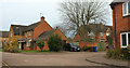
1
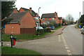
Junction, The Bourne, Hook Norton
With Watery Lane.
Image: © Derek Harper
Taken: 10 Feb 2022
0.02 miles
2
The Bourne, Hook Norton
Passing the junction with The Shearings.
Image: © Derek Harper
Taken: 10 Feb 2022
0.02 miles
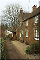
3
Watery Lane, off The Bourne, Hook Norton
I read in the brewery's visitor centre that this got its name from the lane becoming a stream in wet weather (the name of the road at the top end - The Bourne - also suggests a seasonal stream).
Image: © Stephen Craven
Taken: 20 Sep 2021
0.03 miles
4
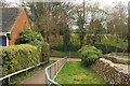
Path to Watery Lane, Hook Norton
Footpath 253 16/10 drops to meet the lane, with a play area on the far side.
Image: © Derek Harper
Taken: 10 Feb 2022
0.05 miles
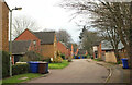
5
Old School End, Hook Norton
A right-angled bend in the cul-de-sac, seen looking back to the left from Image
Image: © Derek Harper
Taken: 10 Feb 2022
0.06 miles
6
Shearing Close, Hook Norton
Footpath 253 17/10 passes the house on its descent to Watery Lane.
Image: © Derek Harper
Taken: 10 Feb 2022
0.07 miles
7
Watery Lane, Hook Norton
The lane becomes too narrow for vehicles as it approaches Netting Street, and the left turn is a footpath - 253 17/10.
Image: © Derek Harper
Taken: 10 Feb 2022
0.08 miles
8
Old School End, Hook Norton
Further along the cul-de-sac seen in Image Footpath 253 16/10 is mapped as following the road.
Image: © Derek Harper
Taken: 10 Feb 2022
0.08 miles
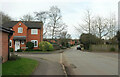
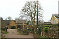
9
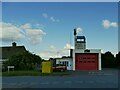
Hook Norton Community Fire Station
A small volunteer brigade.
Image: © Stephen Craven
Taken: 20 Sep 2021
0.09 miles
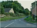
10

Hook Norton fire station
As shown at https://www.geograph.org.uk/gridref/SP3533?centi=SP355333 , but here the door is open.
Image: © Derek Harper
Taken: 10 Feb 2022
0.09 miles