IMAGES TAKEN NEAR TO
The Hill, BANBURY, OX15 5QL
Introduction
This page details the photographs taken nearby to The Hill, OX15 5QL by members of the Geograph project.
The Geograph project started in 2005 with the aim of publishing, organising and preserving representative images for every square kilometre of Great Britain, Ireland and the Isle of Man.

There are currently over 7.5m images from over14,400 individuals and you can help contribute to the project by visiting https://www.geograph.org.uk
Image Map (Loading...)


Getting Data...Please wait
Leaflet Map data © OpenStreetMap
Images are licensed for reuse under creativecommons.org/licenses/by-sa/2.0
Notes
- Clicking on the map will re-center to the selected point.
- The higher the marker number, the further away the image location is from the centre of the postcode.
Image Listing (11 Images Found)
Images are licensed for reuse under creativecommons.org/licenses/by-sa/2.0
Image
Details
Distance
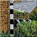
2
Direction Sign – Signpost on Main Street, Sibford Ferris
Located on the southwest side of the crossroads on Main Street in Sibford Ferris parish. 3 arms and annulus finial.
Milestone Society National ID: OX_SP3537B
Image: © W Biswas
Taken: 1 May 2023
0.17 miles
3
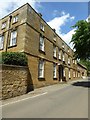
School of the Society of Friends, Sibford Ferris
Walford Manor dates from the 17th century and remodelled in the 18th century. The School of the Society of Friends was established here in 1842. The building is Grade II listed.
Historic England description
SIBFORD FERRIS MAIN STREET SP3436-3536 (North side) 16/143 Sibford School 08/12/55 (Formerly listed as School of the Society of Friends) GV II Manor house now school. C17 remodelled C18. Extended in C19. Rear: regular coursed ironstone rubble. Front: ironstone ashlar. Hipped slate roof. Rendered brick ridge stacks. 3-unit plan extended by the addition of a C19 unit to right and front range forming a double-depth plan. 3 storeys plus attic. 5-window range with further C19 two-window addition on right. Entrance off-centre to left has a tall 6-panelled door in a moulded stone architrave with keyblock head. Flat hood on brackets. 2 semi-circular stone steps and a bootscraper. Entrance is flanked by tall C18 sashes with architrave surrounds and keyblock heads. First floor has 5 similar windows. 1:3:1 bays. Second floor has 4 renewed 2-light casements with keystoned stone lintels. Single pedimented roof dormer. Stone parapet. 2-storeys 2-window C19 extension on right. 2 sash windows with keyblock heads on both ground and first floors. Flat bands to first and second floors. Glazing bars throughout. Rear has a 3-light stone mullioned window with hood mould and label stop. Interior: hall has a substantial stop-chamfered beam, C19 floor tiles and mostly C18 open well staircase. Room to left has C18 panelling. Music room to right has C18 alcove. First floor room on left has dado, windows with seats, shutters and panelled reveals. The Society of Friends established a school here in 1842. (Buildings of England: Oxfordshire: 1974, p766; VCH: 0xfordshire: Vol X, p229)
Source:https://www.historicengland.org.uk/listing/the-list/list-entry/1300140
Image: © Philip Halling
Taken: 7 Jun 2017
0.17 miles
4
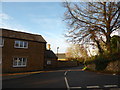
Looking from Main Street into Hawks Lane
Image: © Basher Eyre
Taken: 19 Nov 2017
0.18 miles
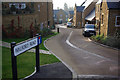
5

Looking from Hawks Lane into Mannings Close
Image: © Basher Eyre
Taken: 19 Nov 2017
0.20 miles
6
Walford Road, Sibford Ferris
Up-market housing development with a nod to traditional Cotswold architecture.
Image: © Stephen McKay
Taken: 4 Feb 2007
0.21 miles
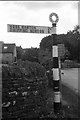
7
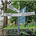
Direction Sign – Signpost on Main Street, Sibford Ferris
Located on the north side of the junction of Main Street, Woodway Road and Hook Norton Road in Sibford Ferris parish. 1 arm but no finial.
Milestone Society National ID: OX_SP3537C
Image: © W Biswas
Taken: 1 May 2023
0.21 miles
8
Direction Sign ? Signpost
Located on the west side of the junction of Hook Norton Road and Woodway Road in Sibford Ferris parish. 1 arm and annulus finial. See also http://www.flickr.com/photos/13171205@N08/3964380176.
Milestone Society National ID: OX_SP3537
Image: © J Mann
Taken: 14 Jun 2020
0.21 miles
9
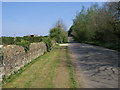
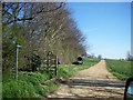
Sibford Road
Sibford Road heading to Sibford Ferris passing Shortlands
Image: © Shaun Ferguson
Taken: 23 Apr 2011
0.21 miles