IMAGES TAKEN NEAR TO
Monmouth Road, OXFORD, OX1 4TD
Introduction
This page details the photographs taken nearby to Monmouth Road, OX1 4TD by members of the Geograph project.
The Geograph project started in 2005 with the aim of publishing, organising and preserving representative images for every square kilometre of Great Britain, Ireland and the Isle of Man.

There are currently over 7.5m images from over14,400 individuals and you can help contribute to the project by visiting https://www.geograph.org.uk
Image Map (Loading...)


Getting Data...Please wait
Leaflet Map data © OpenStreetMap
Images are licensed for reuse under creativecommons.org/licenses/by-sa/2.0
Notes
- Clicking on the map will re-center to the selected point.
- The higher the marker number, the further away the image location is from the centre of the postcode.
Image Listing (74 Images Found)
Images are licensed for reuse under creativecommons.org/licenses/by-sa/2.0
Image
Details
Distance
1
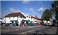
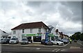
Jewson Skoda
Skoda sales and service, corner of Abingdon Rd. and Northampton Rd.
Image: © Des Blenkinsopp
Taken: 14 Sep 2011
0.04 miles
2
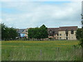
The Four Pillars Hotel, Oxford
In the middle right of the grid square. The site used to be a dairy farm.
Image: © Claire Ward
Taken: 17 Jun 2005
0.06 miles
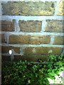
3
Benchmark on #272 Abingdon Road
Ordnance Survey cut mark benchmark described on the Bench Mark Database at http://www.bench-marks.org.uk/bm24301.
Image: © Roger Templeman
Taken: 2 Sep 2010
0.06 miles
4
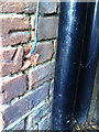
Shops at junction of Abingdon Road and Lincoln Road
There is an OS benchmark Image left of the downpipe on the bicycle shop Ubyk at its junction with the Mediterranean Fish Bar
Image: © Roger Templeman
Taken: 28 Feb 2017
0.06 miles
6
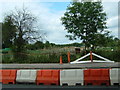
Abingdon Road Allotments
Taken from mid way up the right side of the grid square looking east. There were road works taking place along the Abingdon Road.
Image: © Claire Ward
Taken: 17 Jun 2005
0.08 miles
7
Sunningwell Road, Oxford, 1987
A student shared house (taken the day before I moved out of it).
The back garden appears in Image and Image
Image: © Christopher Hilton
Taken: 29 Jun 1987
0.08 miles
8
Benchmark and snail at #32 Sunningwell Road
Ordnance Survey cut mark benchmark described on the Bench Mark Database at http://www.bench-marks.org.uk/bm35314.
Image: © Roger Templeman
Taken: 2 Sep 2010
0.09 miles
9
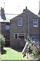
Back of terraced houses, Sunningwell Road, Oxford, 1987
The front of the house is seen in Image
Image: © Christopher Hilton
Taken: 30 Jun 1987
0.09 miles
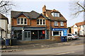
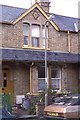
10
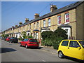
New Hinksey: Sunningwell Road
Victorian terraced houses typical of this area of south Oxford.
Image: © Nigel Cox
Taken: 23 Aug 2007
0.09 miles