IMAGES TAKEN NEAR TO
Hobbyhorse Lane, ABINGDON, OX14 4BB
Introduction
This page details the photographs taken nearby to Hobbyhorse Lane, OX14 4BB by members of the Geograph project.
The Geograph project started in 2005 with the aim of publishing, organising and preserving representative images for every square kilometre of Great Britain, Ireland and the Isle of Man.

There are currently over 7.5m images from over14,400 individuals and you can help contribute to the project by visiting https://www.geograph.org.uk
Image Map
Images are licensed for reuse under creativecommons.org/licenses/by-sa/2.0
Notes
- Clicking on the map will re-center to the selected point.
- The higher the marker number, the further away the image location is from the centre of the postcode.
Image Listing (13 Images Found)
Images are licensed for reuse under creativecommons.org/licenses/by-sa/2.0
Image
Details
Distance
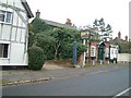
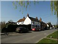
1
Junction of Frilsham Street and High Street
Image: © Roger Templeman
Taken: 1 Sep 2010
0.09 miles
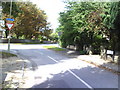
2
Road junction on Harwell Road
At the southern end of Sutton Courtenay. Dominated by the Didcot power station.
Image: © David Lally
Taken: 17 Dec 2010
0.12 miles
3
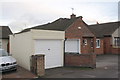
#89 High Street and garage of #87
There is an Ordnance Survey cut mark benchmark (described on the Bench Mark Database at http://www.bench-marks.org.uk/bm22890 ) in the bricks of the garage to the right of its doors.
Image: © Roger Templeman
Taken: 22 Dec 2011
0.13 miles
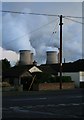
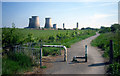
4
Junction of Cycle Route 5 and Hobbyhorse Lane
The National Cycle Network Route 5 finger post reads Didcot 2.75m, Sutton Courtenay 0.25m. The cooling towers and chimney stacks of Didcot Power Stations in the background.
Image: © Roger Templeman
Taken: 22 Dec 2011
0.13 miles
5
Sutton Courtenay Post Office: late March 2022
Image: © Basher Eyre
Taken: 26 Mar 2022
0.15 miles
6
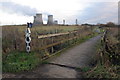
Cycleway Metalwork
I agree that you need something to keep 4 wheelers off the cycleway, but this all looks a bit random, like it's bits off something else.
I suppose it does the trick. It just looks a bit trashy, that's all.
Image: © Des Blenkinsopp
Taken: 4 May 2011
0.15 miles
7

Farmland and cycle network signpost, Sutton Courtenay
At the point where the cycle route leaves Hobbyhorse Lane and heads south towards Didcot.
Image: © Andrew Smith
Taken: 7 May 2008
0.20 miles
8
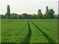
Farmland, Sutton Courtenay
Wheat to the north of Hobbyhorse Lane.
Image: © Andrew Smith
Taken: 7 May 2008
0.20 miles
9
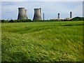
Farmland and cooling towers, Sutton Courtenay
Barley between the village and the remains of Didcot's coal-fired power station.
Image: © Andrew Smith
Taken: 1 Jun 2019
0.20 miles