IMAGES TAKEN NEAR TO
Westwater Way, DIDCOT, OX11 7SN
Introduction
This page details the photographs taken nearby to Westwater Way, OX11 7SN by members of the Geograph project.
The Geograph project started in 2005 with the aim of publishing, organising and preserving representative images for every square kilometre of Great Britain, Ireland and the Isle of Man.

There are currently over 7.5m images from over14,400 individuals and you can help contribute to the project by visiting https://www.geograph.org.uk
Image Map
Images are licensed for reuse under creativecommons.org/licenses/by-sa/2.0
Notes
- Clicking on the map will re-center to the selected point.
- The higher the marker number, the further away the image location is from the centre of the postcode.
Image Listing (15 Images Found)
Images are licensed for reuse under creativecommons.org/licenses/by-sa/2.0
Image
Details
Distance
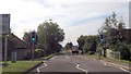
1

Abingdon Road, Didcot
Looking towards Trent Road
Image: © David Howard
Taken: 29 May 2016
0.09 miles
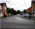
2
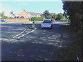
Mini roundabout on Abingdon Road
The road going left is Trent Road, that going right Upperway Furlong.
Image: © Roger Templeman
Taken: 9 Sep 2010
0.11 miles
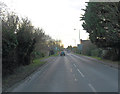
3
Abingdon Road approaching Trent Road roundabout
Image: © John Firth
Taken: 20 Sep 2013
0.11 miles
4
A4130 junction with Trent Road
The junction comprises a mini-roundabout and the 'A' road is also called Abingdon road.
Image: © Stuart Logan
Taken: 4 Feb 2012
0.12 miles
5
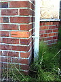
Benchmark on #100 Abingdon Road
Ordnance Survey cut mark benchmark described on the Bench Mark Database at http://www.bench-marks.org.uk/bm22103.
Image: © Roger Templeman
Taken: 9 Sep 2010
0.12 miles
6

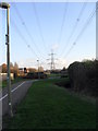
Pylons and Cables in Didcot
With a major power station on the edge of town it's inevitable that lines like this are a feature of the local landscape.
Building has to keep a suitably safe distance away from them, resulting in North Didcot having a long open strip like this running through the centre of recent housing developments.
The area beneath the cables has been landscaped into a sort of linear park, with cycleways and sitting out areas, and is actually a bit of an amenity.
Image: © Des Blenkinsopp
Taken: 3 Aug 2011
0.14 miles
7

Loddon Drive, Didcot
This newly built part of Didcot is far from being a boring load of identikit boxes.
House shapes and styles are quite varied, including some of these retro bow fronted ones which could have come straight out of the 1930s, right down to the coloured glass flower motifs just visible in the lower quarter lights.
All the roads here have river names. The River Loddon flows into the Thames near Reading.
Image: © Des Blenkinsopp
Taken: 3 Aug 2011
0.15 miles
8
Ladygrove
National Grid power lines in Didcot.
Image: © Burgess Von Thunen
Taken: 15 Jan 2013
0.15 miles
9
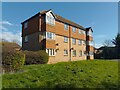
33-49 Washford Glen, Didcot
A block of flats facing Tamar Way.
Image: © Oscar Taylor
Taken: 3 Mar 2024
0.22 miles
10
Plym Drive, Didcot
From the south side of Mersey Way, Plym Drive leads to Ray Court (ahead on the left), Foudry Close and Jordan Close.
Image: © Jaggery
Taken: 3 Sep 2017
0.22 miles