IMAGES TAKEN NEAR TO
Roman Fields, DIDCOT, OX11 0UF
Introduction
This page details the photographs taken nearby to Roman Fields, OX11 0UF by members of the Geograph project.
The Geograph project started in 2005 with the aim of publishing, organising and preserving representative images for every square kilometre of Great Britain, Ireland and the Isle of Man.

There are currently over 7.5m images from over14,400 individuals and you can help contribute to the project by visiting https://www.geograph.org.uk
Image Map
Images are licensed for reuse under creativecommons.org/licenses/by-sa/2.0
Notes
- Clicking on the map will re-center to the selected point.
- The higher the marker number, the further away the image location is from the centre of the postcode.
Image Listing (65 Images Found)
Images are licensed for reuse under creativecommons.org/licenses/by-sa/2.0
Image
Details
Distance
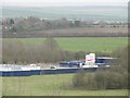
1
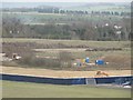
Diggers on site
Diggers can be seen clearing the old topsoil in preparation for the new housing being built here at Harwell. This used to be the old RAF bomb store.
Image: © Bill Nicholls
Taken: 28 Nov 2011
0.05 miles
2
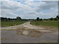
Towards the Dump
I'm sure this was the old bomb dump at RAF Harwell, it was cleared a few years ago of old waste that had been stored there over the years by Harwell and was forgotten about.
Image: © Bill Nicholls
Taken: 4 Jun 2011
0.06 miles
3
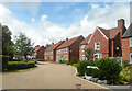
Potteries Lane, Chilton
Part of an extensive new housing development which has expanded Chilton village onto the west side of the A34.
Image: © Des Blenkinsopp
Taken: 7 Aug 2021
0.07 miles
4
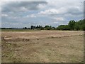
Topsoil cleared away
I spotted this work going on from where I work so I thought it was worth looking at, seems they could be doing an archaeological dig here.
Image: © Bill Nicholls
Taken: 4 Jun 2011
0.08 miles
5
Compound at the end
This will be the works compound for the building site that is for the new housing development at Harwell.
Image: © Bill Nicholls
Taken: 28 Nov 2011
0.08 miles
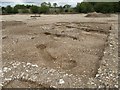
6
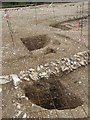
Storage pits
These, it turns out, were storage pits for grain, the Iron Age Britons used to use them, the Romans built over them. At the present time this area is now a construction site, I managed to get these photos before development started.
Image: © Bill Nicholls
Taken: 12 Aug 2011
0.08 miles
7
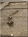
Roundhouse in the footings
The Roman building was built on top of an old Iron Age roundhouse it seems; the gullies here are where the rain dripped off the thatched roof. At the present time this area is now a construction site, I managed to get these photos before it started.
Image: © Bill Nicholls
Taken: 12 Aug 2011
0.08 miles
8
Back to the dig
Back for a few more of the archaeological dig on the old RAF Harwell site before the new homes are built. At the present time this area is now a construction site, I managed to get these photos before it started.
Image: © Bill Nicholls
Taken: 12 Aug 2011
0.08 miles
9
Post holes and gully
More of the rain gully and post holes from the Iron Age Roundhouse at the Harwell Dig. At the present time this area is now a construction site, I managed to get these photos before it started.
Image: © Bill Nicholls
Taken: 12 Aug 2011
0.08 miles
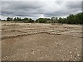
10
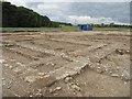
Foundations of a building
Which turns out to be Roman. To the left, where the blue container is, the old RAF Taxiway runs. At the present time this area is now a construction site, I managed to get these photos before it started.
Image: © Bill Nicholls
Taken: 12 Aug 2011
0.08 miles