IMAGES TAKEN NEAR TO
St. Georges Close, WALLINGFORD, OX10 9NF
Introduction
This page details the photographs taken nearby to St. Georges Close, OX10 9NF by members of the Geograph project.
The Geograph project started in 2005 with the aim of publishing, organising and preserving representative images for every square kilometre of Great Britain, Ireland and the Isle of Man.

There are currently over 7.5m images from over14,400 individuals and you can help contribute to the project by visiting https://www.geograph.org.uk
Image Map (Loading...)


Getting Data...Please wait
Leaflet Map data © OpenStreetMap
Images are licensed for reuse under creativecommons.org/licenses/by-sa/2.0
Notes
- Clicking on the map will re-center to the selected point.
- The higher the marker number, the further away the image location is from the centre of the postcode.
Image Listing (942 Images Found)
Images are licensed for reuse under creativecommons.org/licenses/by-sa/2.0
Image
Details
Distance
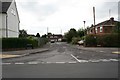
1
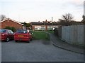
St Georges Close
Until recently I never realised the place was here, just thought it was a car park.
Image: © Bill Nicholls
Taken: 8 Apr 2008
0.02 miles
2
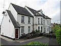
Flats on Honey Lane
A friend of mine used to live here back in the 1950s when it was a family home. He moved away and the place was sold. Some years later the place fell vacant and became derelict; the orchard surrounding it was sold off and became Brookside. The house was taken over by the council, made into flats and an extension built. Now the place is going downhill again and plans are afoot for the place to be demolished and three dwellings built. A sad end for a once great house.
Image: © Bill Nicholls
Taken: 29 May 2011
0.03 miles
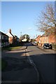
3
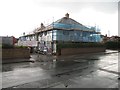
New housing on Honey Lane
The old house which had been converted into flats has been demolished and now these new houses take its place. Image
Image: © Bill Nicholls
Taken: 20 Apr 2012
0.03 miles
4

New one on Brookside
Some of the houses are on Brookside so will be taking the Numbers from 1A, they replace the flats that used to be here. Image
Image: © Bill Nicholls
Taken: 20 Apr 2012
0.03 miles
5
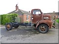
Rat Look Truck
Must admit I have never seen this one driving around, been wondering it is going to be restored along Crescent Way in Cholsey.
If you do not have a clue about what Rat Look is the have a look at http://rat-look.com/what-is-rat-look/
Image: © Bill Nicholls
Taken: 31 Dec 2015
0.04 miles
6
Brookside
No, not the one featured in the soap. The whole estate is built on an old apple orchard, many a time we used to scrump there.
Image: © Bill Nicholls
Taken: 25 Aug 2008
0.04 miles
7
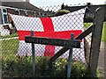
St Georges Close
St Georges flag as a backdrop for the road sign, quite apt really considering it was St Georges Day yesterday
Image: © Bill Nicholls
Taken: 24 Apr 2020
0.04 miles
8
New building on Honey Lane
Looking along Honey lane in Cholsey towards some building work going on.
Image: © Bill Nicholls
Taken: 20 Apr 2012
0.04 miles
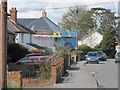
9
Honey lane
Honey lane with Buckthorn lane junction on the left. The block of flats to the left were built back around 1960.
Image: © Bill Nicholls
Taken: 18 Jan 2009
0.05 miles
10

Punky snowman
A punky snowman along Buckthorn lane Cholsey
Image: © Bill Nicholls
Taken: 9 Jan 2010
0.05 miles