IMAGES TAKEN NEAR TO
St. Georges Road, WALLINGFORD, OX10 8HR
Introduction
This page details the photographs taken nearby to St. Georges Road, OX10 8HR by members of the Geograph project.
The Geograph project started in 2005 with the aim of publishing, organising and preserving representative images for every square kilometre of Great Britain, Ireland and the Isle of Man.

There are currently over 7.5m images from over14,400 individuals and you can help contribute to the project by visiting https://www.geograph.org.uk
Image Map
Images are licensed for reuse under creativecommons.org/licenses/by-sa/2.0
Notes
- Clicking on the map will re-center to the selected point.
- The higher the marker number, the further away the image location is from the centre of the postcode.
Image Listing (163 Images Found)
Images are licensed for reuse under creativecommons.org/licenses/by-sa/2.0
Image
Details
Distance
1
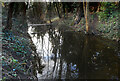
The Saxon Moat
Wallingford's Saxon fortifications are well preserved for most of their length, but especially so here where the moat still holds water 1,000 years on.
Image: © Des Blenkinsopp
Taken: 29 Jan 2010
0.07 miles
2
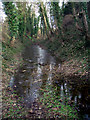
Water in the Moat
Marked rather inaccurately as "drain" on the map, this is part of Wallingford's Saxon moat which was dug in the reign of King Alfred to create one of the fortified towns of Wessex.
A bit further along from my 2010 picture Image the moat has even more water in it this year.
Image: © Des Blenkinsopp
Taken: 25 Feb 2021
0.09 miles
3
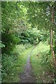
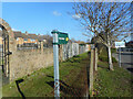
On by the Bullcroft
Footpath leading past the Bullcroft and onto St Georges road.
Image: © Bill Nicholls
Taken: 10 Aug 2008
0.09 miles
4
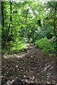
Ditch towards St Georges Road
The Fortifications ditch looking the other way. Image
Image: © Bill Nicholls
Taken: 10 Aug 2008
0.10 miles
5
Wallingford's Shortest Footpath?
Shown on the map as following the edge of a school field to Castle Street at the other end, the path is no longer in existence beyond the 20 metres or so visible here, where bushes take over.
For a long time there has been a road following the same route a short distance away, and the path is redundant but I guess nobody has gone through the rigmarole of officially closing it. There is even a recent looking signpost at this end, as seen here.
Image: © Des Blenkinsopp
Taken: 27 Feb 2021
0.10 miles
6
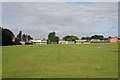
Wallingford School
Wallingford School , gone through a few name changes but I know it as Blackstone.
Image: © Bill Nicholls
Taken: 10 Aug 2008
0.11 miles
7
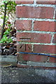
Benchmark on #21 St Georges Road
Ordnance Survey cut mark benchmark described on the Bench Mark Database at http://www.bench-marks.org.uk/bm21794
Image: © Roger Templeman
Taken: 20 Dec 2013
0.11 miles
8
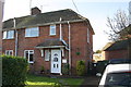
#21 St Georges Road
There is an OS benchmark Image on the near corner of the house above the side path
Image: © Roger Templeman
Taken: 20 Dec 2013
0.11 miles
9
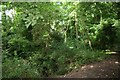
Ditch here some where
The Saxon Fortification ditch is down there in the undergrowth.
Image: © Bill Nicholls
Taken: 10 Aug 2008
0.11 miles
10
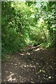
Bullcroft Ditch
The Ditch by the Saxon Fortifications of the Bullcroft.
Image: © Bill Nicholls
Taken: 10 Aug 2008
0.11 miles