IMAGES TAKEN NEAR TO
Barncroft, WALLINGFORD, OX10 8HN
Introduction
This page details the photographs taken nearby to Barncroft, OX10 8HN by members of the Geograph project.
The Geograph project started in 2005 with the aim of publishing, organising and preserving representative images for every square kilometre of Great Britain, Ireland and the Isle of Man.

There are currently over 7.5m images from over14,400 individuals and you can help contribute to the project by visiting https://www.geograph.org.uk
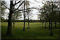
Image Map (Loading...)


Getting Data...Please wait
Leaflet Map data © OpenStreetMap
Images are licensed for reuse under creativecommons.org/licenses/by-sa/2.0
Notes
- Clicking on the map will re-center to the selected point.
- The higher the marker number, the further away the image location is from the centre of the postcode.
Image Listing (137 Images Found)
Images are licensed for reuse under creativecommons.org/licenses/by-sa/2.0
Image
Details
Distance
1
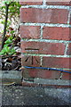
Benchmark on #21 St Georges Road
Ordnance Survey cut mark benchmark described on the Bench Mark Database at http://www.bench-marks.org.uk/bm21794
Image: © Roger Templeman
Taken: 20 Dec 2013
0.04 miles
2
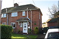
#21 St Georges Road
There is an OS benchmark Image on the near corner of the house above the side path
Image: © Roger Templeman
Taken: 20 Dec 2013
0.04 miles
3
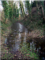
The Saxon Moat
Wallingford's Saxon fortifications are well preserved for most of their length, but especially so here where the moat still holds water 1,000 years on.
Image: © Des Blenkinsopp
Taken: 29 Jan 2010
0.07 miles
4
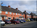
Clapcot Way
Away from the historic town centre, a lot of Wallingford is much like anywhere else.
The town stayed within its ancient boundaries for centuries before sprawling out post WW2 into the surrounding fields.
This is Clapcot Way, a name which harks back to one of the old parishes that occupied the surrounding area in days gone by. http://www.british-history.ac.uk/report.aspx?compid=43259
The rest of the street is much the same as this. I just liked the Ho Ho Ho house.
Image: © Des Blenkinsopp
Taken: 29 Jan 2010
0.10 miles
5
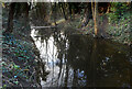
Water in the Moat
Marked rather inaccurately as "drain" on the map, this is part of Wallingford's Saxon moat which was dug in the reign of King Alfred to create one of the fortified towns of Wessex.
A bit further along from my 2010 picture Image the moat has even more water in it this year.
Image: © Des Blenkinsopp
Taken: 25 Feb 2021
0.10 miles
6
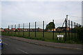
What's left
This is what is left of the school playing fields.
Image: © Bill Nicholls
Taken: 26 Apr 2008
0.10 miles
7
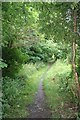
On by the Bullcroft
Footpath leading past the Bullcroft and onto St Georges road.
Image: © Bill Nicholls
Taken: 10 Aug 2008
0.10 miles
8
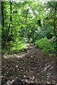
Ditch towards St Georges Road
The Fortifications ditch looking the other way. Image
Image: © Bill Nicholls
Taken: 10 Aug 2008
0.12 miles
9
Back across the park
Looking across the Bull Croft from near the monument.
Image: © Bill Nicholls
Taken: 26 Apr 2008
0.12 miles
10

Club house end
The bowling green towards the club house end.
Image: © Bill Nicholls
Taken: 10 Aug 2008
0.12 miles