IMAGES TAKEN NEAR TO
Wilding Road, WALLINGFORD, OX10 8AJ
Introduction
This page details the photographs taken nearby to Wilding Road, OX10 8AJ by members of the Geograph project.
The Geograph project started in 2005 with the aim of publishing, organising and preserving representative images for every square kilometre of Great Britain, Ireland and the Isle of Man.

There are currently over 7.5m images from over14,400 individuals and you can help contribute to the project by visiting https://www.geograph.org.uk
Image Map (Loading...)


Getting Data...Please wait
Leaflet Map data © OpenStreetMap
Images are licensed for reuse under creativecommons.org/licenses/by-sa/2.0
Notes
- Clicking on the map will re-center to the selected point.
- The higher the marker number, the further away the image location is from the centre of the postcode.
Image Listing (24 Images Found)
Images are licensed for reuse under creativecommons.org/licenses/by-sa/2.0
Image
Details
Distance
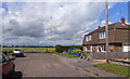
1
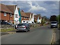
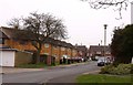
Wilding Road, Wallingford
Some of the local authority built housing on the northern edge of the town.
Image: © Andrew Smith
Taken: 18 May 2019
0.01 miles
2
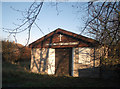
Wigod Way Christian Centre
This poor little chapel didn't have a very long life.
There are already a lot of churches in Wallingford. I suppose this was too tucked away on the edge of town to get enough congregation.
It's pronounced "wye god" by the way.
Update:- The chapel has recently been acquired for conversion to a young people's centre.
Image: © Des Blenkinsopp
Taken: 3 Jan 2010
0.03 miles
3
Blackstone Road
Judge William Blackstone, 1723 - 1780, Oxford academic, MP, author of "Commentaries on the laws of England" and all round good chap, was one of Wallingford's most famous residents www.berkshirehistory.com/bios/wblackstone.HTML
It only seems fair that he should have a road named after him.
Image: © Des Blenkinsopp
Taken: 2 Jan 2010
0.07 miles

5
Wallingford's Shortest Footpath?
Shown on the map as following the edge of a school field to Castle Street at the other end, the path is no longer in existence beyond the 20 metres or so visible here, where bushes take over.
For a long time there has been a road following the same route a short distance away, and the path is redundant but I guess nobody has gone through the rigmarole of officially closing it. There is even a recent looking signpost at this end, as seen here.
Image: © Des Blenkinsopp
Taken: 27 Feb 2021
0.09 miles
7
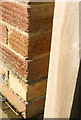
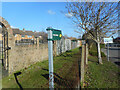
Benchmark on #79 Nicholas Road
Ordnance Survey cut mark benchmark, on 4th and 5th bricks above ground and left of a wooden gatepost, described on the Bench Mark Database at http://www.bench-marks.org.uk/bm23444
Image: © Roger Templeman
Taken: 20 Dec 2013
0.12 miles
8
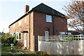
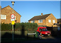
#79 St Nicholas Road
There is an OS benchmark Image on the near corner of the house left of the wooden gatepost for the metal gate
Image: © Roger Templeman
Taken: 20 Dec 2013
0.12 miles
9
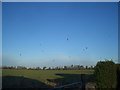
Empty Field with Kites
A rather blurry, low light picture of over 15 Red Kites circling over this empty field to the north of Wallingford.
It's hard to believe these birds were once on the brink of extinction. In fact they were extinct in this area prior to their very successful reintroduction.
This large field is currently one of the sites on the edge of town attracting the unwelcome gaze of house builders.
Tell them it's a nature reserve with rare birds on it.
Image: © Des Blenkinsopp
Taken: 2 Jan 2010
0.14 miles
10
Doyley Road, Wallingford
Residential Wallingford stops at these field gates at the end of Doyley Road, a short street with around half a dozen houses.
Image: © Des Blenkinsopp
Taken: 22 Jun 2011
0.14 miles