IMAGES TAKEN NEAR TO
Revell Close, WALLINGFORD, OX10 0TH
Introduction
This page details the photographs taken nearby to Revell Close, OX10 0TH by members of the Geograph project.
The Geograph project started in 2005 with the aim of publishing, organising and preserving representative images for every square kilometre of Great Britain, Ireland and the Isle of Man.

There are currently over 7.5m images from over14,400 individuals and you can help contribute to the project by visiting https://www.geograph.org.uk
Image Map (Loading...)


Getting Data...Please wait
Leaflet Map data © OpenStreetMap
Images are licensed for reuse under creativecommons.org/licenses/by-sa/2.0
Notes
- Clicking on the map will re-center to the selected point.
- The higher the marker number, the further away the image location is from the centre of the postcode.
Image Listing (96 Images Found)
Images are licensed for reuse under creativecommons.org/licenses/by-sa/2.0
Image
Details
Distance
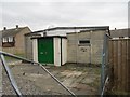
1
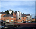
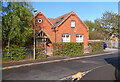
Revell Close
Off Beeching Way. So new it's not on the map.
This area as well as being the site of Wallingford train station was also home to the town Gas Works in the days when gas was manufactured from coal.
This was a very dirty process and there were substantial pollution issues to be solved before housing could be built.
Image: © Des Blenkinsopp
Taken: 4 Feb 2010
0.04 miles
3
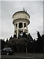
Telecommunications on to
Mobile phone equipment can be seen here on top of the water tower at Wallingford
Image: © Bill Nicholls
Taken: 13 Feb 2010
0.05 miles
4
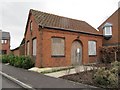
Side of the pumping station
I came here to see if there was a bench mark on the pump house and by chance saw one person who lived here in the housing beside it. They were good enough to let me photograph it from this side which shows what looks like a porch was here at one time. No bench mark though, I found out it was probably on the water tower that used to be here but was demolished, this is all that is left now.
Image: © Bill Nicholls
Taken: 13 Feb 2010
0.06 miles
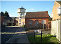
5
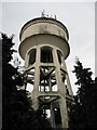
Tower by the trees
One of the things that dominate the centre of Wallingford is this water tower that now stands in a housing estate.
Image: © Bill Nicholls
Taken: 13 Feb 2010
0.06 miles
6
Tower and pumping station
View of the water tower and pumping station. The original water tower would have been nearer the pump house.
Image: © Bill Nicholls
Taken: 13 Feb 2010
0.06 miles
7
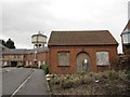
Converted Pumping Station Building, Beeching Way
A nice conversion of a building which was part of an old pumping station.
An earlier picture from 2010 Image shows it empty and boarded up. It's good to see it with a new life as it's quite a pleasant old building.
Image: © Des Blenkinsopp
Taken: 5 May 2021
0.06 miles
8
Pumping station by the housing
The water tower on its own in the middle of a housing estate. I must confess it was a while since I had been round the area so was surprised it had changed.
Image: © Bill Nicholls
Taken: 13 Feb 2010
0.06 miles
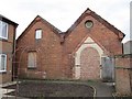
9
Derelict scout hut
I might be wrong but I'm quite sure this is the old second Wallingford scout group hall.
Image: © Bill Nicholls
Taken: 13 Feb 2010
0.06 miles
10
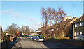
Beeching Way
Beeching Way is on the site of the terminus of the old branch line which used to run between the main line at Cholsey and Wallingford Station, which was near here. The station closed to passengers in 1959 and no trace remains.
Dr Richard Beeching in 1963 produced a report which resulted in the closure of many lines and stations, and Wallingford would undoubtedly have been one of them if events hadn't beaten him to it.
But as this road is on the site of a closed station, the name is relevant.
The small boarded up building was part of an old pumping station. Since this picture was taken it has been converted to a house, shown here Image
Image: © Des Blenkinsopp
Taken: 30 Jan 2010
0.06 miles