IMAGES TAKEN NEAR TO
Buttermere Road, ASHTON-UNDER-LYNE, OL7 9EW
Introduction
This page details the photographs taken nearby to Buttermere Road, OL7 9EW by members of the Geograph project.
The Geograph project started in 2005 with the aim of publishing, organising and preserving representative images for every square kilometre of Great Britain, Ireland and the Isle of Man.

There are currently over 7.5m images from over14,400 individuals and you can help contribute to the project by visiting https://www.geograph.org.uk
Image Map (Loading...)


Getting Data...Please wait
Leaflet Map data © OpenStreetMap
Images are licensed for reuse under creativecommons.org/licenses/by-sa/2.0
Notes
- Clicking on the map will re-center to the selected point.
- The higher the marker number, the further away the image location is from the centre of the postcode.
Image Listing (74 Images Found)
Images are licensed for reuse under creativecommons.org/licenses/by-sa/2.0
Image
Details
Distance
1
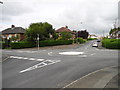
Mini Roundabout, Knowle Avenue
Looking across to Ullswater Avenue from Coniston Grove. Crowhill area of Ashton-under-Lyne.
Image: © John Topping
Taken: 13 Sep 2012
0.10 miles
2
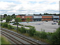
Credit Crunched!
A sign of the times at this retail park outside Ashton. One half is still used for a Sainsbury's store, but this half is vacant, with one retailer clearly having ceased trading.
Image: © Peter Whatley
Taken: 13 Jul 2009
0.13 miles
4

Sainsbury's Ashton-Under-Lyne
A view towards Sainsbury's supermarket from the roof-top car park at IKEA.
Image: © David Dixon
Taken: 15 May 2015
0.14 miles
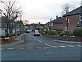
5
Knowle Avenue (2)
Looking west from Taunton Road. Crowhill area of Ashton-under-Lyne.
Image: © John Topping
Taken: 13 Sep 2012
0.15 miles
6
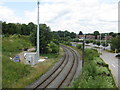
Ashton Moss Curve
The railway line curves sharply between the site of the former Ashton Moss South Junction (now obliterated) and the main Manchester-Ashton line. Just visible are electrification masts for this distant offshoot of the 1950s Manchester-Sheffield-Wath electrification scheme.
Image: © Peter Whatley
Taken: 13 Jul 2009
0.16 miles
7
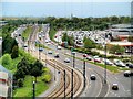
Lord Sheldon Way
Viewed here from the roof car park at the IKEA store, Lord Sheldon Way (A6140) is the town's north western bypass across Ashton Moss. The road is named after Baron Sheldon who, as Robert Sheldon, was Ashton's Member of Parliament between 1964 and 2001 and long-serving chairman of the House of Commons Public Accounts Committee.
Sainsbury's supermarket is on the right hand side of the road.
Image: © David Dixon
Taken: 15 May 2015
0.16 miles
9
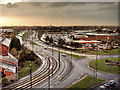
Ashton-Under-Lyne, Lord Sheldon Way
Viewed here from the IKEA store, Lord Sheldon Way (A6140) is the town's north western bypass across Ashton Moss. The road is named after Baron Sheldon who, as Robert Sheldon, was Ashton's Member of Parliament between 1964 and 2001 and long-serving chairman of the House of Commons Public Accounts Committee.
Sainsbury's supermarket is on the right hand side of the road.
Image: © David Dixon
Taken: 8 Dec 2015
0.17 miles
10
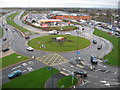
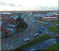
Sainsbury's Island Ashton under Lyne
The traffic island here only opened fully in October 2006.
The dual carriageway to the left is Lord Sheldon Way which is the new link road from Ashton to the M60 ring road.
The tallest building on the horizon in the far distance to the left is Image about 9 miles away.
Picture taken from roof of Image
Image: © Paul Anderson
Taken: 4 Mar 2007
0.17 miles