IMAGES TAKEN NEAR TO
Chester Square, ASHTON-UNDER-LYNE, OL6 7TW
Introduction
This page details the photographs taken nearby to Chester Square, OL6 7TW by members of the Geograph project.
The Geograph project started in 2005 with the aim of publishing, organising and preserving representative images for every square kilometre of Great Britain, Ireland and the Isle of Man.

There are currently over 7.5m images from over14,400 individuals and you can help contribute to the project by visiting https://www.geograph.org.uk
Image Map
Images are licensed for reuse under creativecommons.org/licenses/by-sa/2.0
Notes
- Clicking on the map will re-center to the selected point.
- The higher the marker number, the further away the image location is from the centre of the postcode.
Image Listing (305 Images Found)
Images are licensed for reuse under creativecommons.org/licenses/by-sa/2.0
Image
Details
Distance
1

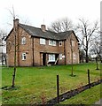
1881 Westfield
Name and date stone on a house on Manchester Road Image
Image: © Gerald England
Taken: 27 Feb 2016
0.05 miles
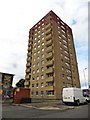
2
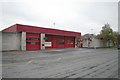
Ashton-under-Lyne fire station
Ashton-under-Lyne fire station, Hodgson Street, Ashton-under-Lyne, Greater Manchester
Image: © Kevin Hale
Taken: 31 Oct 2007
0.05 miles
3
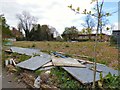
Getting ready for London Living
Richmond House which originally stood on part of this site was used in the First World War as an auxiliary hospital. York House, also on this site was at one time a hotel and restaurant with a reputation for fine dining. It closed (I'm not sure when) and subsequently demolished after suffering fire damage. Planning permission for building houses on the site was granted in 2008 but the site was still derelict in 2016 Image Now work is about to start on a development of "18 Prestigious Homes" called "London Living".
Image: © Gerald England
Taken: 23 Apr 2017
0.05 miles
4

Westfield, Manchester Road
Large house dated 1881 Image It has been converted into offices.
Image: © Gerald England
Taken: 27 Feb 2016
0.05 miles
5
Site of York House & Richmond House
Richmond House which originally stood on part of this site was used in the First World War as an auxiliary hospital. York House, also on this site was at one time a hotel and restaurant with a reputation for fine dining. It closed (I'm not sure when) and subsequently demolished after suffering fire damage. Planning permission for building houses on the site was granted in 2008 but the site remains derelict.
Image: © Gerald England
Taken: 27 Feb 2016
0.05 miles
6
Site of York House & Richmond House
Richmond House which originally stood on part of this site was used in the First World War as an auxiliary hospital. York House, also on this site was at one time a hotel and restaurant with a reputation for fine dining. It closed (I'm not sure when) and subsequently demolished after suffering fire damage. Planning permission for building houses on the site was granted in 2008 but the site was still derelict in 2016 Image Now work is about to start on a development of "18 Prestigious Homes" called "London Living".
Image: © Gerald England
Taken: 23 Apr 2017
0.05 miles
7
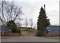
St Peter's Vicarage
Originally the vicarage of St Peter's church, the house was boarded up for many years. It is now owned and used by St Peter’s Partnerships, a registered charity which provides support and services within the St Peter’s ward of Ashton-under-Lyne, in Greater Manchester.http://web.archive.org/web/20120312055819/http://www.stpeterspartnerships.org/frequently-asked-questions.html
Image: © Gerald England
Taken: 24 Feb 2012
0.06 miles
9
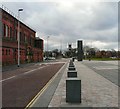
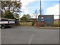
Stamford Street West
Looking West down Stamford Street West. On the left hand side is the old Ashton Baths Image The right hand side was once rows of terraced houses and shops but these have all been cleared at part of St Petersfield development. To the right (out of picture) is the new Magistrates Court. In the background lies St Peter's Church Image
Image: © Gerald England
Taken: 24 Feb 2012
0.06 miles
10
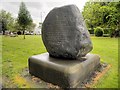
The Boulton Bowlder
Memorial in the churchyard of Image
The inscription reads:
"This Bowlder
was placed here by
Alderman Isaac Watt Boulton MP
of Stamford House Ashton under Lyme
in affectionate remembrance of
his eldest son
Thomas Boulton
who was for 9 years warden of this church
Born November 5th 1841
and died at sea February 5th 1880
on board the R.M.S.S Kinpauns Castle
wherest on a voyage to the Cape of Good Hope
to recruit his health
his remains were committed to the deep
in Lat.11.30 South Long.2.30 West, February 8th 1880
Lord have mercy on my soul
and take me to thee"
Note the spelling Ashton under Lyme (not Lyne) was common in the 19th century (also "bowlder" for "boulder").
Manchester Road is in the background.
Image: © David Dixon
Taken: 28 May 2014
0.06 miles