IMAGES TAKEN NEAR TO
Margaret Street, ASHTON-UNDER-LYNE, OL6 7RF
Introduction
This page details the photographs taken nearby to Margaret Street, OL6 7RF by members of the Geograph project.
The Geograph project started in 2005 with the aim of publishing, organising and preserving representative images for every square kilometre of Great Britain, Ireland and the Isle of Man.

There are currently over 7.5m images from over14,400 individuals and you can help contribute to the project by visiting https://www.geograph.org.uk
Image Map
Images are licensed for reuse under creativecommons.org/licenses/by-sa/2.0
Notes
- Clicking on the map will re-center to the selected point.
- The higher the marker number, the further away the image location is from the centre of the postcode.
Image Listing (436 Images Found)
Images are licensed for reuse under creativecommons.org/licenses/by-sa/2.0
Image
Details
Distance
1
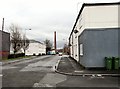
Margaret Street
Leading down to Junction Mills.
Image: © Gerald England
Taken: 24 Feb 2012
0.02 miles
2
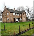
St Peter's Vicarage
Originally the vicarage of St Peter's church, the house was boarded up for many years. It is now owned and used by St Peter’s Partnerships, a registered charity which provides support and services within the St Peter’s ward of Ashton-under-Lyne, in Greater Manchester.http://web.archive.org/web/20120312055819/http://www.stpeterspartnerships.org/frequently-asked-questions.html
Image: © Gerald England
Taken: 24 Feb 2012
0.06 miles
3
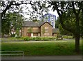
Vicarage boarded up
St Peter's Vicarage Centre is presently boarded up. The whole of the West End Park, within which lies St Peter's church, has been recently refurbished.
Image: © Gerald England
Taken: 23 Jul 2008
0.06 miles
4

Taxiland
A garage specialising in servicing taxis, housed in the former Victoria Corn Mill on Victoria Street.
Image: © Gerald England
Taken: 21 Mar 2015
0.07 miles
5
Stamford Street West
Looking West down Stamford Street West. On the left hand side is the old Ashton Baths Image The right hand side was once rows of terraced houses and shops but these have all been cleared at part of St Petersfield development. To the right (out of picture) is the new Magistrates Court. In the background lies St Peter's Church Image
Image: © Gerald England
Taken: 24 Feb 2012
0.07 miles
6
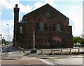
Hugh Mason House a.k.a. Ashton Old Baths
The Corporation Baths were opened in 1870 at a cost of £16,000. The building is constructed almost entirely of brick, with some stone decoration. It was built in a Byzantine style and has a 120 feet high tower which housed the flues from the steam boilers and heaters. The main pool was 100 feet long and 40 feet wide and used mainly by male bathers, with a three hour period on Thursdays reserved for ladies. In the eastern section of the building was a smaller pool, 27 feet long and 15 feet wide, for the use of female bathers. During the winter months, when the main bath was closed, the smaller pool was used by men and women at different times. There were also private bathrooms and Turkish baths. Part of the building was used as a police station and a station for one fire engine.
Between November and March each year, the main pool was covered over with a wooden floor, built on wooden supports placed on the bottom of the pool. The room was then used as a skating rink, concert hall and meeting room. The skating rink measured 116 by 50 feet with a raised stage area at one end. When chairs were set out, the ground floor and the spacious gallery could seat more than 4,000 people. http://www.ashton-under-lyne.com/history/baths.htm
The building was closed in the 1970s. In 1975 it became Grade II listed. http://www.britishlistedbuildings.co.uk/en-212657-hugh-mason-house-ashton-under-lyne The listing has saved it from demolition but even as part of the St Petersfield development area Image a new use for it has yet to be found.
In the foreground is the Ashton Munitions Explosion Memorial Image
Image
Image: © Gerald England
Taken: 4 Aug 2014
0.07 miles
7
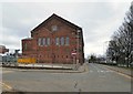
Fleet Street
On the right is the inner bypass, Park Parade. On the left is the Old Baths.
The Corporation Baths Image were opened in 1870 at a cost of £16,000. The main pool was 100 feet long and 40 feet wide and used mainly by male bathers, with a three hour period on Thursdays reserved for ladies. In the eastern section of the building was a smaller pool, 27 feet long and 15 feet wide, for the use of female bathers. There were also private bathrooms and Turkish baths. Part of the building was used as a police station and a station for one fire engine. In winter the main pool was covered over with a wooden floor, built on wooden supports placed on the bottom of the pool. The room was then used as a skating rink, concert hall and meeting room http://www.ashton-under-lyne.com/history/baths.htm.
The building was closed in the 1970s. In 1975 it became Grade II* listed https://historicengland.org.uk/listing/the-list/list-entry/1067992?section=official-list-entry. In 2014 the building was acquired by PlaceFirstLtd and work began to transform it into 21st century business hub.
At 19:30 on Saturday 19th March 2016 a free event unfolded outside the baths. The "New Beginnings" event combined digital projections, choreographed dancing, and a thematic soundtrack telling the story of Ashton Old Baths through interwoven audio-visual acts in an action packed 45 minute display.
Image: © Gerald England
Taken: 19 Mar 2016
0.08 miles
8

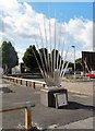
Ashton Munitions Explosion memorial
Erected within the St.Petersfield redevelopment area.
Although the actual explosion http://en.wikipedia.org/wiki/Ashton-under-Lyne_munitions_explosion occurred a few hundred yards away, many local premises were affected, and one fatality, a child, resulted from glass falling from the roof of the swimming baths into the pool below.
The sculpture http://www.ashton-under-lyne.com/history/explosion.htm is placed close to the old baths building.
Image: © Alan Murray-Rust
Taken: 7 Jan 2014
0.08 miles
9
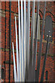
Ashton Munitions Explosion memorial - detail
Erected within the St.Petersfield redevelopment area.
Although the actual explosion http://en.wikipedia.org/wiki/Ashton-under-Lyne_munitions_explosion occurred a few hundred yards away, many local premises were affected, and one fatality, a child, resulted from glass falling from the roof of the swimming baths into the pool below.
The sculpture http://www.ashton-under-lyne.com/history/explosion.htm is placed close to the old baths building.
Image: © Alan Murray-Rust
Taken: 7 Jan 2014
0.08 miles
10
Ashton Munitions Explosion Memorial
The Ashton Munitions Explosion Memorial is sculpture by Paul Margetts. The sculpture is fabricated in stainless steel and electro-polished. It stands 3.5 metres high above a plinth. http://www.forging-ahead.co.uk/Ashton%20Munitions%20Sculpture.htm
According to the plaque on the front:
"This sculpture was designed with considerable help from children at St. Peter's Primary School, Ashton to remember
THE ASHTON MUNITIONS EXPLOSION.
At 4.22pm on Wednesday 13 June 1917, 5 tons of TNT exploded at the
Hooley Hill Rubber and Chemicals Factory on William Street,
near to Oxford Street in Ashton.
A plaque is located near to the site of the disaster on William Street to commemorate where
46 people were killed and more than 400 were injured with hundreds more made homeless.
Many of those killed were children on their way home from school on that fine June afternoon."
For more information see Wikipedia: http://en.wikipedia.org/wiki/Ashton-under-Lyne_munitions_explosion
GM 1914: The First World War in Greater Manchester: http://gm1914.wordpress.com/2014/01/30/tragedy-on-the-home-front-munitions-explosion-in-ashton/
BBC World War One At Home: http://www.bbc.co.uk/programmes/p01q7vd4
For a list of the victims see http://www.c5d.co.uk/munitionsfactory.php
Image: © Gerald England
Taken: 4 Aug 2014
0.08 miles