IMAGES TAKEN NEAR TO
Moss Terrace, ASHTON-UNDER-LYNE, OL6 7BW
Introduction
This page details the photographs taken nearby to Moss Terrace, OL6 7BW by members of the Geograph project.
The Geograph project started in 2005 with the aim of publishing, organising and preserving representative images for every square kilometre of Great Britain, Ireland and the Isle of Man.

There are currently over 7.5m images from over14,400 individuals and you can help contribute to the project by visiting https://www.geograph.org.uk
Image Map (Loading...)


Getting Data...Please wait
Leaflet Map data © OpenStreetMap
Images are licensed for reuse under creativecommons.org/licenses/by-sa/2.0
Notes
- Clicking on the map will re-center to the selected point.
- The higher the marker number, the further away the image location is from the centre of the postcode.
Image Listing (317 Images Found)
Images are licensed for reuse under creativecommons.org/licenses/by-sa/2.0
Image
Details
Distance
1
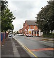
Katherine Street
A busy route for buses from Ashton to Manchester.
Image: © Gerald England
Taken: 28 Jul 2009
0.01 miles
2
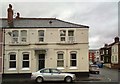
Corner of Katherine Street and Welbeck Street North
The house on the corner was formerly the Welbeck Hotel Image
Image: © Gerald England
Taken: 5 Feb 2014
0.03 miles
3
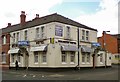
Welbeck Hotel
Welbeck Hotel on Katherine Street.
Image: © Gerald England
Taken: 19 Jun 2012
0.03 miles
4
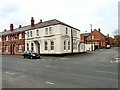
Welbeck House
The former Welbeck House Hotel Image on Katherine Street has been converted into (presumably) apartments.
Image: © Gerald England
Taken: 2 Apr 2013
0.03 miles
5
Welbeck Street Baptist Church
The first Baptist chapel in Ashton opened on Hodgson Street in 1848. By the 1960s the old church, following two fires in the 1950s had become very dilapidated. A new site, at the junction of Welbeck Street South and Brook Street East was purchased, and compensation from the council enabled the church to demolish the old building and begin work on the new one. The work was completed by July 1965, with the first service taking place on September 19th. In September 2010, Ayi Samson Ake from Ivory Coast became their new Lay Pastor. More information on the church website: http://www.welbeckstreetbc.nwba.org.uk/history.php
Image: © Gerald England
Taken: 3 Sep 2012
0.06 miles
6
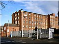
Portland Mill
The building that survives today was built in 1850 as an extension to the original 1824 cotton mill. Production ceased in 1903 and the original mill has since been demolished. http://ashton-under-lyne.blogspot.co.uk/2008/10/portland-mill.html
It is now occupied a number of businesses including the Olympic Sports Gym http://www.olympicsportsgym.co.uk/ Tameside Store 'n' Go http://www.tamesidestorengoselfstorage.co.uk/ Boutique Goddess https://www.boutiquegoddess.co.uk/ Sitsiam Camp (Home of Thai martial arts) http://sitsiam-camp.com/ and the Top Cricket Indoor Netting Facility http://top-cricket-indoor-netting-facility.business.site/
Note: Photograph is for record purposes only. The photographer has no personal connection with any of the businesses mentioned.
Image: © Gerald England
Taken: 15 Dec 2017
0.06 miles
7
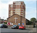
Richmond Park
In the middle of the one-way system that is Margaret Street and Richmond Street there is a small open space with benches around some standing stones.
The estate on the right is Richmond Park. The tower blocks and maisonettes were built in 1965, using the BISON prefabricated building system. Along with the West End estate, they are owned by Ashton Pioneer Homes http://www.ashtonpioneerhomes.co.uk/ an arms length management organisation formed in 1999, that took over operations hitherto carried out by Tameside MBC's housing department.
Katherine Street on the left is named after the wife of George Henry Grey, the Seventh Earl of Stamford. His wife, whom George married on the 29 August 1855, was a circus bareback rider. https://mancunian1001.wordpress.com/2013/02/14/down-our-street-6-katherine-street-and-penny-meadow-ashton-under-lyne/
Image: © Gerald England
Taken: 27 Feb 2016
0.07 miles
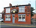
8
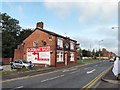
Margaret Street
The Ring o Bells Image on the corner of Moss Street and Margaret Street. Once surrounded by terraced house, by the 1980s it was surrounded by light industry. Now Margaret Street is part of the one-way system at the West End of Ashton between Katherine Street and Chester Square. The now somewhat isolated pub was originally a beerhouse owned by James Wood from 1863 to 1882. It became a Bents and Gartside's pub in 1939 and granted a full licence in 1953. It became a Bass pub in 1967 but is now a free house.
Image: © Gerald England
Taken: 3 Sep 2012
0.07 miles
9
Ring o Bells
Once surrounded by terraced house, by the 1980s it was surrounded by light industry. Now Margaret Street Image is part of the one-way system at the West End of Ashton between Katherine Street and Chester Square. The now somewhat isolated pub was originally a beerhouse owned by James Wood from 1863 to 1882. It became a Bents and Gartside's pub in 1939 and granted a full licence in 1953. It became a Bass pub in 1967 but is now a free house.
Image
Image
Image: © Gerald England
Taken: 3 Sep 2012
0.07 miles
10
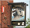
Sign of the Ring o Bells
Sign for the Ring o Bells Image
Image: © Gerald England
Taken: 3 Sep 2012
0.07 miles