IMAGES TAKEN NEAR TO
Manchester Road, ASHTON-UNDER-LYNE, OL5 9BP
Introduction
This page details the photographs taken nearby to Manchester Road, OL5 9BP by members of the Geograph project.
The Geograph project started in 2005 with the aim of publishing, organising and preserving representative images for every square kilometre of Great Britain, Ireland and the Isle of Man.

There are currently over 7.5m images from over14,400 individuals and you can help contribute to the project by visiting https://www.geograph.org.uk
Image Map (Loading...)


Getting Data...Please wait
Leaflet Map data © OpenStreetMap
Images are licensed for reuse under creativecommons.org/licenses/by-sa/2.0
Notes
- Clicking on the map will re-center to the selected point.
- The higher the marker number, the further away the image location is from the centre of the postcode.
Image Listing (72 Images Found)
Images are licensed for reuse under creativecommons.org/licenses/by-sa/2.0
Image
Details
Distance
1
Welcome to Mossley: Welcome to Tameside
Along Manchester Road, at its junction with Shadows Lane, is the boundary between the Metropolitan Borough of Oldham and the Metropolitan Borough of Tameside, which in turn is the boundary between Saddleworth (specifically Greenfield) and Mossley respectively.
The boundary is marked by various welcome signage, including the one pictured here for both Mossley and Tameside.
Image: © Steven Haslington
Taken: 15 May 2012
0.01 miles
2
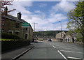
Mossley: Junction of A635 with Calf Lane
The site of the Roaches SHMD tram terminus.
Image: © Dr Neil Clifton
Taken: 12 Jun 2015
0.01 miles
3
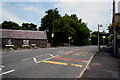
Mossley: Shadows Lane
The Mossley boundary runs along the right-hand side of this lane, so that these houses are just in Mossley.
Image: © Dr Neil Clifton
Taken: 12 Jun 2015
0.01 miles
4

Old Boundary Marker by the A635, Manchester Road, Mossley
County Boundary Marker by the A635 Manchester Road Y-junction with Shadows Lane, on East side of junction, opposite Calf Lane. On the boundary of Saddleworth and Mossley parishes, formerly Yorkshire and Cheshire but now Oldham and Tameside.
Defaced inscription reads:-
: COUNTY OF / ?? / ?? : : BOUNDARY : : COUNTY OF / ?? / ?? / HUNDRED / BOROUGH OF / ?? :
Surveyed
Milestone Society National ID: YW_SADMOS01cb
Image: © R Heywood
Taken: Unknown
0.01 miles
5
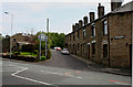
Mossley: Lodge on Manchester Road
The Mossley borough boundary crosses the main road (A635) here. The lane coming down from the left is Calf Lane. This is where the Roaches terminus of the SHMD trams (Stalybridge, Hyde, Mossley & Dukinfield Tramways & Electricity Board) was situated. The lodge is a former toll house erected by the Ridgehill, Lanes & Holehouse Turnpike Trust.
Image: © Dr Neil Clifton
Taken: 12 Jun 2015
0.01 miles
6
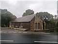
Ex Toll House, Manchester Road
Former Toll House originally servicing/erected by the Ridgehill, Lanes & Holehouse Turnpike Trust at the corner of Calf Lane where the Mossley borough boundary with Saddleworth crosses the main road (A635).
The Image can be seen opposite.
The Oldham Way long distance footpath also follows the boundary in this region.
"Stalybridge, Hyde, Mossley & Dukinfield Tramways" terminus was at this location.
Milestone Society National ID: MA.MOS01
Image: © Nigel Upton
Taken: 25 Oct 2022
0.01 miles
7
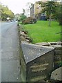
County boundary
Yorkshire/Lancashire boundary stone with detail chiselled out during WWII to confuse the enemy.
Image: © David Watson
Taken: 22 Oct 2007
0.03 miles
8
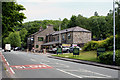
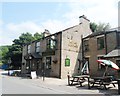
A635: The 'Royal George'
The SHMD trams came within about 100 yards of this large pub. But that was back in the 1930s! however, you can still get a bus to here from Mossley centre. The large establishment appears to be prospering - it has the advantage of being on a main road.
Image: © Dr Neil Clifton
Taken: 12 Jun 2015
0.06 miles
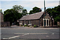
9
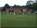
Saddleworth Cricket Club Pavilion
Saddleworth CC play in the Saddleworth & District League.
The obelisk near Aldermans Hill can be seen in the background.
Image: © BatAndBall
Taken: 7 Jul 2011
0.07 miles