IMAGES TAKEN NEAR TO
Quickedge Road, ASHTON-UNDER-LYNE, OL5 0PT
Introduction
This page details the photographs taken nearby to Quickedge Road, OL5 0PT by members of the Geograph project.
The Geograph project started in 2005 with the aim of publishing, organising and preserving representative images for every square kilometre of Great Britain, Ireland and the Isle of Man.

There are currently over 7.5m images from over14,400 individuals and you can help contribute to the project by visiting https://www.geograph.org.uk
Image Map
Images are licensed for reuse under creativecommons.org/licenses/by-sa/2.0
Notes
- Clicking on the map will re-center to the selected point.
- The higher the marker number, the further away the image location is from the centre of the postcode.
Image Listing (17 Images Found)
Images are licensed for reuse under creativecommons.org/licenses/by-sa/2.0
Image
Details
Distance
1
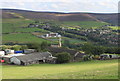
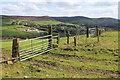
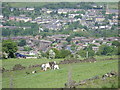
The Tame valley from Quickedge Road near Mossley
Little Haigh Farm is in the foreground with St. John's Church at Roughtown beyond.
Image: © Michael Fox
Taken: 15 Aug 2011
0.13 miles
2
Quickedge Road
Approaching Hawthorn Farm at Quick Edge.
Image: © David Dixon
Taken: 12 Dec 2011
0.16 miles
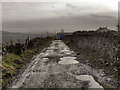
3
Quick Edge
Parked in Sandbed, then up road to summit in field and then bagged the top of the covered reservoir just in case.
Name: Quick Edge
Hill number: 16652
Height: 294m / 965ft
Parent (Ma/M): 2810 Black Hill
Section: 36: Lancashire, Cheshire & the Southern Pennines
County/UA: Tameside (UA)
Class: Tump (200-299m)
Grid ref: SD 97111 03374
Summit feature: ground in field S of covered water tank
Drop: 36m
Col: 258m SD974041
Image: © Rude Health
Taken: 1 May 2015
0.17 miles
4
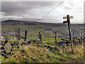
Signpost and Stile, Quick Edge
The path to Roughtown from Quickedge Road.
Image: © David Dixon
Taken: 12 Dec 2011
0.17 miles
5
The Tame Valley from near Little Haigh Farm
The stile gives access to a path to the Roughtown area of Mossley, the spire of St John's church at which is in the centre of the picture. In the distance on the left is the recently completed replacement for Mossley Hollins School.
Image: © Michael Fox
Taken: 15 Aug 2011
0.19 miles
6
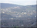
Roughtown/Micklehurst
A view above Micklehurst with Roughtown in the background. Taken from Buckton Hill.
Image: © Richard Brierley
Taken: 2 Mar 2009
0.19 miles
7
Elizabeth II postbox on Stockport Road, Mossley
Image: © JThomas
Taken: 2 Nov 2018
0.20 miles
8
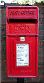
Close up, Elizabeth II postbox on Stockport Road, Mossley
Postbox No. OL5 119.
See Image] for wider view.
Image: © JThomas
Taken: 2 Nov 2018
0.20 miles
9
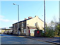
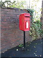
Houses on Stockport Road, Mossley
Showing position of Postbox No. OL5 119.
See Image] for postbox.
Image: © JThomas
Taken: 2 Nov 2018
0.20 miles
10
Micklehurst with Roughtown in the distance
Image: © Richard Brierley
Taken: 1 Jun 2009
0.21 miles