IMAGES TAKEN NEAR TO
Milnrow Road, OLDHAM, OL2 8BL
Introduction
This page details the photographs taken nearby to Milnrow Road, OL2 8BL by members of the Geograph project.
The Geograph project started in 2005 with the aim of publishing, organising and preserving representative images for every square kilometre of Great Britain, Ireland and the Isle of Man.

There are currently over 7.5m images from over14,400 individuals and you can help contribute to the project by visiting https://www.geograph.org.uk
Image Map
Images are licensed for reuse under creativecommons.org/licenses/by-sa/2.0
Notes
- Clicking on the map will re-center to the selected point.
- The higher the marker number, the further away the image location is from the centre of the postcode.
Image Listing (42 Images Found)
Images are licensed for reuse under creativecommons.org/licenses/by-sa/2.0
Image
Details
Distance
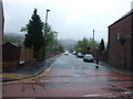
2
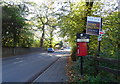
Milnrow Road (A663)
Looking south showing position of Postbox No. OL2 220.
See Image] for postbox.
Image: © JThomas
Taken: 18 Oct 2018
0.06 miles
3
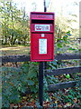
Elizabeth II postbox on Milnrow Road (A663)
Postbox No. OL2 220.
See Image] for context.
Image: © JThomas
Taken: 18 Oct 2018
0.07 miles
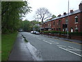
5
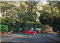
Milnrow Road from Dunwood Park Courts
The car is heading towards Shaw on Milnrow Road (A663). The narrow road climbing into the distance is Higher Park.
Image: © michael ely
Taken: 22 Oct 2011
0.07 miles
7
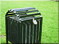
Why the padlock on a litter bin?
Dunwood Park, Wood End, Shaw.
Image: © Ian S
Taken: 11 Sep 2010
0.12 miles
8
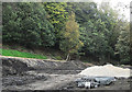
Dunwood Park amphitheatre
Construction has begun on a new piece of public realm work in the middle of the park's low level promenade.
Image: © michael ely
Taken: 4 Oct 2011
0.12 miles
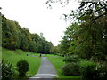
9
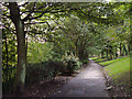
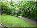
Dunwood Park, Shaw
Looking south along the main footpath through the park about 100 metres north of the tennis courts. The path runs parallel with the railway and the River Beal.
Image: © michael ely
Taken: 20 Sep 2007
0.13 miles