IMAGES TAKEN NEAR TO
Moor House Fold, ROCHDALE, OL16 4DH
Introduction
This page details the photographs taken nearby to Moor House Fold, OL16 4DH by members of the Geograph project.
The Geograph project started in 2005 with the aim of publishing, organising and preserving representative images for every square kilometre of Great Britain, Ireland and the Isle of Man.

There are currently over 7.5m images from over14,400 individuals and you can help contribute to the project by visiting https://www.geograph.org.uk
Image Map (Loading...)


Getting Data...Please wait
Leaflet Map data © OpenStreetMap
Images are licensed for reuse under creativecommons.org/licenses/by-sa/2.0
Notes
- Clicking on the map will re-center to the selected point.
- The higher the marker number, the further away the image location is from the centre of the postcode.
Image Listing (41 Images Found)
Images are licensed for reuse under creativecommons.org/licenses/by-sa/2.0
Image
Details
Distance
1
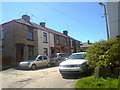
Whitehead Street, Milnrow
Whitehead Street in Milnrow, Greater Manchester, England.
Image: © Steven Haslington
Taken: 3 Jun 2011
0.10 miles
2
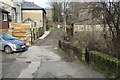
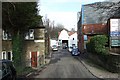
Shore Street
An unadopted street near the centre of Milnrow.
Image: © Bryan Tenny
Taken: 17 Feb 2011
0.11 miles
4
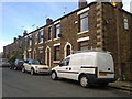
Halliwell Street, Milnrow
A row of houses on Halliwell Street, in Milnrow, Greater Manchester, England. This type of stone terraced housing is typical of Milnrow.
Image: © Steven Haslington
Taken: 23 May 2011
0.13 miles
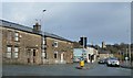
5
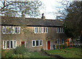
Stone cottages, Milnrow
This attractive row of cottages is at the very end of Dale St - Milnrow's main shopping street. Although rural in character they couldn't be closer to all amenities.
Image: © michael ely
Taken: 25 Nov 2005
0.13 miles
6
Lily Street
Situated in Milnrow near the junction of Bridge St with Dale St.
Image: © Bryan Tenny
Taken: 17 Feb 2011
0.14 miles
7
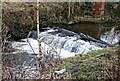
River Beal Weir
The weir on the river Beal in Milnrow from which Weir Rd in the 1970s housing estate on the site of Ashes farm takes its name.
Image: © Bryan Tenny
Taken: 17 Jan 2011
0.14 miles
8
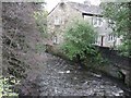
River Beal from Milnrow Bridge
The Beal flows from Shaw through Newhey and Milnrow to join the Roch
Image: © Bryan Tenny
Taken: Unknown
0.14 miles
9
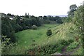
The Beal Valley
Viewed from Ashes Lane, the Beal Valley contains the River Beal, a tributary of the Roch, which is itself a tributary of the River Irwell.
Image: © Bryan Tenny
Taken: 29 Sep 2020
0.15 miles
10
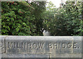
Milnrow Bridge
Spanning the River Beal on Bridge Street at the bottom of Kiln Lane. View downstream.
Image: © michael ely
Taken: 8 Sep 2011
0.16 miles