IMAGES TAKEN NEAR TO
Stock Grove, ROCHDALE, OL16 3XB
Introduction
This page details the photographs taken nearby to Stock Grove, OL16 3XB by members of the Geograph project.
The Geograph project started in 2005 with the aim of publishing, organising and preserving representative images for every square kilometre of Great Britain, Ireland and the Isle of Man.

There are currently over 7.5m images from over14,400 individuals and you can help contribute to the project by visiting https://www.geograph.org.uk
Image Map (Loading...)


Getting Data...Please wait
Leaflet Map data © OpenStreetMap
Images are licensed for reuse under creativecommons.org/licenses/by-sa/2.0
Notes
- Clicking on the map will re-center to the selected point.
- The higher the marker number, the further away the image location is from the centre of the postcode.
Image Listing (56 Images Found)
Images are licensed for reuse under creativecommons.org/licenses/by-sa/2.0
Image
Details
Distance
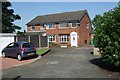
1
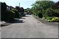
Stock Grove
This view of Stock Grove was taken from the vehicle turning area at the end of the cul-de-sac. Part of a 1970 housing estate in Milnrow.
Image: © Bryan Tenny
Taken: 19 Apr 2011
0.01 miles
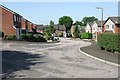
2
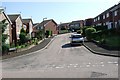
Stock Grove from Weir Road
Part of a late 1970s housing development in Milnrow.
Image: © Bryan Tenny
Taken: 19 Apr 2011
0.01 miles
3
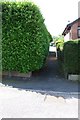
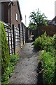
Alley from Weir Road to Stock Grove
This is an alley from Weir Road to Stock Grove on the 1970s Ashes Farm estate in Milnrow.
Image: © Bryan Tenny
Taken: Unknown
0.03 miles
4
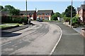
Weir Road
Another view of Weir Road, part of a 1970s housing estate in Milnrow. Weir Road is a no through road built on a hill and has two bends. This view is taken from the lower bend towards the hill.
Image: © Bryan Tenny
Taken: 19 Apr 2011
0.04 miles
5
Alley to Croft Head Drive
This alley runs from Stock Grove to Croft Head Drive on the 1970s Ashes Farm estate in Milnrow
Image: © Bryan Tenny
Taken: Unknown
0.04 miles
6
Stock Grove towards Weir Road
Another view of Stock Grove. Part of a 1970s housing estate in Milnrow.
Image: © Bryan Tenny
Taken: 19 Apr 2011
0.04 miles
7
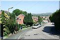
Weir Road
Weir Road is a no through road. Part of a 1970s/80s housing estate in Milnrow, the road has two bends. This view is taken down the hill from the upper bend.
Image: © Bryan Tenny
Taken: 19 Apr 2011
0.04 miles
8
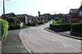
Weir Road
Another view of Weir Road, part of a 1970s housing estate in Milnrow. Weir Road is a no through road built on a hill and has two bends. This view is taken from the lower bend towards the end of the road.
Image: © Bryan Tenny
Taken: 19 Apr 2011
0.05 miles
9
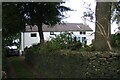
Ashes Farm
Situated on Ashes Lane this was an active farm until the mid 1970s when its fields were sold off for building. Its grounds contain the grave of John Stock after whom the nearby Stock Grove on the farm's former fields was built.
Image: © Bryan Tenny
Taken: 29 Sep 2020
0.07 miles
10
Beal Croft Walk
Beal Croft Walk, part of a 1980s housing estate in Milnrow. This view taken from its junction with Weir Road.
Image: © Bryan Tenny
Taken: 19 Apr 2011
0.07 miles