IMAGES TAKEN NEAR TO
Botesworth Green, ROCHDALE, OL16 3PJ
Introduction
This page details the photographs taken nearby to Botesworth Green, OL16 3PJ by members of the Geograph project.
The Geograph project started in 2005 with the aim of publishing, organising and preserving representative images for every square kilometre of Great Britain, Ireland and the Isle of Man.

There are currently over 7.5m images from over14,400 individuals and you can help contribute to the project by visiting https://www.geograph.org.uk
Image Map (Loading...)


Getting Data...Please wait
Leaflet Map data © OpenStreetMap
Images are licensed for reuse under creativecommons.org/licenses/by-sa/2.0
Notes
- Clicking on the map will re-center to the selected point.
- The higher the marker number, the further away the image location is from the centre of the postcode.
Image Listing (84 Images Found)
Images are licensed for reuse under creativecommons.org/licenses/by-sa/2.0
Image
Details
Distance
1
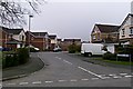
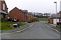
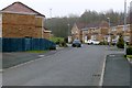
Botesworth Green
A housing estate built on part of the playing fields of Hollingworth Business & enterprise College in Milnrow
Image: © Bryan Tenny
Taken: 16 Mar 2011
0.02 miles
2
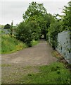
Old Tramway Route
The route was to Butterworth Hall from Tunshill collieries. This view is near the Butterworth Hall end in Milnrow
Image: © Kevin Waterhouse
Taken: 17 Aug 2020
0.05 miles
3
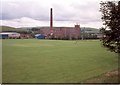
Butterworth Hall Mill : 1996
Milnrow's last cotton mill. Demolition had already begun at the time of this photo. A housing estate has since been built on the site.
Image: © Paul Hogg
Taken: Unknown
0.06 miles
4
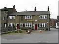
The Waggon Inn, Milnrow
This old public house is situated very close to the point where coal, coming down a tramroad from Tunshill Colliery, would be transferred into horse-drawn waggons for onward distribution.
Image: © Dr Neil Clifton
Taken: 18 Sep 2009
0.06 miles
5
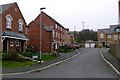
Butterworth Close
A new Millennium housing estate in Milnrow built off Water Lane on the site of Butterworth Hall mill, near Botesworth Green.
Image: © Bryan Tenny
Taken: 16 Mar 2011
0.07 miles
6
Heys Close
Part of the new Millennium housing estate built off Water lane in Milnrow on the site of Butterworth hall mill. Named after Hey farm?
Image: © Bryan Tenny
Taken: 16 Mar 2011
0.07 miles
7
Charles Lane 1992
Looking along Charles Lane with Butterworth Hall Mill in the background.
Image: © Paul Hogg
Taken: Unknown
0.07 miles
8
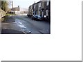
No 1, Good Intent, Milnrow
The houses on Good Intent back directly on to those in Charles Lane, so we have examples still in 2009 of occupied and cared-for back-to-back houses. The footpath in the photograph leads into Charles Lane.
Image: © Dr Neil Clifton
Taken: 18 Sep 2009
0.07 miles
9
Cressbrook Way
Part of the new Millennium housing estate built between Water Lane and the M62 embankment on the site of Butterworth Hall mill.
Image: © Bryan Tenny
Taken: 16 Mar 2011
0.07 miles
10
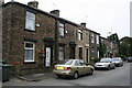
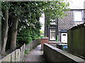
Nos. 50 to 36, Charles Lane, Milnrow
Pleasant old lane on the east side of this village - which could at one time have been referred to as a mining village. Butterworth Hall colliery was very near to this point, and several other collieries within walking distance. But all were closed long ago.
Image: © Dr Neil Clifton
Taken: 18 Sep 2009
0.08 miles