IMAGES TAKEN NEAR TO
Caton Street, ROCHDALE, OL16 1QJ
Introduction
This page details the photographs taken nearby to Caton Street, OL16 1QJ by members of the Geograph project.
The Geograph project started in 2005 with the aim of publishing, organising and preserving representative images for every square kilometre of Great Britain, Ireland and the Isle of Man.

There are currently over 7.5m images from over14,400 individuals and you can help contribute to the project by visiting https://www.geograph.org.uk
Image Map
Images are licensed for reuse under creativecommons.org/licenses/by-sa/2.0
Notes
- Clicking on the map will re-center to the selected point.
- The higher the marker number, the further away the image location is from the centre of the postcode.
Image Listing (395 Images Found)
Images are licensed for reuse under creativecommons.org/licenses/by-sa/2.0
Image
Details
Distance
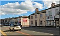
1
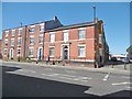
Rochdale, Cloth Hall
On Drake Street. The name of the building seems to indicate that it was once an exchange for merchants and manufacturers, presumably of wool and cotton, but no source seems to tie the building into this use. Now occupied by accountants.
Image: © Mike Faherty
Taken: 21 Sep 2019
0.01 miles
2
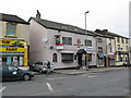
The 'Navigation Inn', Drake Street, Rochdale
The name of this public house gives the clue to its age, as just across the road there used to be the terminal basin of the Rochdale Branch Canal. This canal, north of the junction with the main line at Lock Bridge, has been filled in.
Image: © Dr Neil Clifton
Taken: 23 Feb 2009
0.03 miles
3
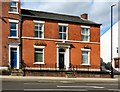
Cloth Hall
The premises at 150 Drake Street are currently the offices of an accountant. Back in 1844 it was owned by a Mr Butterworth who was offered £20 for it by the Rochdale Pioneers provided he made it tenable. In the end however they found much cheaper premises on Toad Lane so that is where the Co-op movement began instead of here.
Image: © Gerald England
Taken: 22 Sep 2016
0.03 miles
4
Pennine Solicitors, Drake Street, Rochdale
Image: © Stephen Craven
Taken: 26 Nov 2018
0.04 miles
5
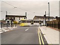
Tram on Maclure Road
Metrolink Bombardier tram 3058 seen on Maclure Road, heading towards the Rochdale terminus, on the day that a tram service ran into the town centre for the first time in 80 years (http://www.manchestereveningnews.co.uk/news/greater-manchester-news/rochdales-first-passenger-tram-80-6897266 Manchester Evening News).
The Oldham and Rochdale Metrolink line was completed when the extension to Rochdale Town Centre opened on 31st March, 2014. The Rochdale town centre extension continues from Image] along Maclure Road before running downhill along Drake Street. The route terminates at Rochdale Town Centre stop on the north side of Smith Street.
Image: © David Dixon
Taken: 31 Mar 2014
0.04 miles
6
Rochdale: Two more defunct pubs
On Drake Street, near the top of Maclure Road. The left hand pub was the 'Nevigation' and the name is still displayed. The other one, now quite derelict, was the 'Woolpack'.
Image: © Dr Neil Clifton
Taken: 18 Mar 2011
0.05 miles
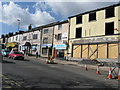
7
Drake Street Rochdale - Before the Trams Arrive
Image: © Anthony Parkes
Taken: 12 Feb 2011
0.05 miles
8

The Nelson public house from Ann Street
A Sam Smith's pub in Rochdale.
Image: © Ian S
Taken: 20 Sep 2011
0.05 miles
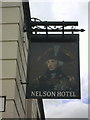
10
Drake Street
The A640 in Rochdale. On the corner is The Nelson.
Image: © Gerald England
Taken: 22 Sep 2016
0.05 miles