IMAGES TAKEN NEAR TO
Church Lane, ROCHDALE, OL16 1NR
Introduction
This page details the photographs taken nearby to Church Lane, OL16 1NR by members of the Geograph project.
The Geograph project started in 2005 with the aim of publishing, organising and preserving representative images for every square kilometre of Great Britain, Ireland and the Isle of Man.

There are currently over 7.5m images from over14,400 individuals and you can help contribute to the project by visiting https://www.geograph.org.uk
Image Map
Images are licensed for reuse under creativecommons.org/licenses/by-sa/2.0
Notes
- Clicking on the map will re-center to the selected point.
- The higher the marker number, the further away the image location is from the centre of the postcode.
Image Listing (516 Images Found)
Images are licensed for reuse under creativecommons.org/licenses/by-sa/2.0
Image
Details
Distance
1
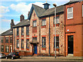
Institute For The Deaf
Church Lane, Rochdale
Image: © David Dixon
Taken: 30 Jun 2010
0.01 miles
2
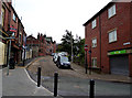
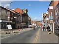
Rochdale: Church Lane
Looking south from its junction with Fleece Street. Three hundred years ago, a traveller to Oldham would have begun his journey this way.
Image: © Dr Neil Clifton
Taken: 21 Sep 2013
0.02 miles
3
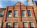
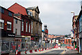
Trafalgar Buildings, Rochdale, Lancashire (Detail)
Image: © Robert Wade
Taken: 29 Jan 2011
0.02 miles
4
Drake Street, Rochdale, Lancashire
Trafalgar Buildings, Rochdale, Lancashire on the left
Image: © Robert Wade
Taken: 29 Jan 2011
0.02 miles
5
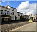
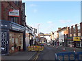
Tram on Drake Street
A tram climbs up Drake Street.
Image: © Gerald England
Taken: 22 Sep 2016
0.02 miles
6
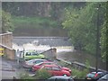
Rochdale weir
Standing in car park looking towards Yelloways old station
Image: © R lee
Taken: 26 May 2006
0.02 miles
7
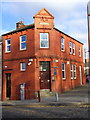
"Craig Lee House" 25 Church Lane, Rochdale, Lancashire OL12 6LB
Image: © Robert Wade
Taken: 29 Jan 2011
0.02 miles
8
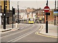
Rochdale, Drake Street
Metrolink Bombardier tram 3058 climbs the hill at Drake Street on the day that a tram service ran into the town centre for the first time in 80 years (http://www.manchestereveningnews.co.uk/news/greater-manchester-news/rochdales-first-passenger-tram-80-6897266 Manchester Evening News).
The Oldham and Rochdale Metrolink line was completed when the extension to Rochdale Town Centre opened on 31st March, 2014. The Rochdale town centre extension continues from Image] along Maclure Road before running downhill along Drake Street. The route terminates at Rochdale Town Centre stop on the north side of Smith Street.
Image: © David Dixon
Taken: 31 Mar 2014
0.02 miles
9
Rochdale: View down Drake Street
Showing the lower part of the street. The tall building on the left hand side is the Champness Hall.
Image: © Dr Neil Clifton
Taken: 18 Mar 2011
0.02 miles
10
Rochdale: Drake Street
Looking north, from just beyond the Water Street junction. Southbound buses use Water Street and regain their normal route here, but the northbound equivalents must use Wood Street and whole length of Molesworth Street to reach the bus station. On the left here is seen the once-prestigious Champness Hall, looking rather sorry for itself in the middle of all this mess.
Image: © Dr Neil Clifton
Taken: 8 Sep 2012
0.02 miles