IMAGES TAKEN NEAR TO
Calderbrook Road, LITTLEBOROUGH, OL15 9NP
Introduction
This page details the photographs taken nearby to Calderbrook Road, OL15 9NP by members of the Geograph project.
The Geograph project started in 2005 with the aim of publishing, organising and preserving representative images for every square kilometre of Great Britain, Ireland and the Isle of Man.

There are currently over 7.5m images from over14,400 individuals and you can help contribute to the project by visiting https://www.geograph.org.uk
Image Map
Images are licensed for reuse under creativecommons.org/licenses/by-sa/2.0
Notes
- Clicking on the map will re-center to the selected point.
- The higher the marker number, the further away the image location is from the centre of the postcode.
Image Listing (31 Images Found)
Images are licensed for reuse under creativecommons.org/licenses/by-sa/2.0
Image
Details
Distance
1
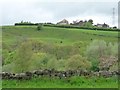
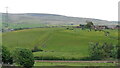
Whitfield Farm, above the valley of the River Roch
Seen from the Rochdale Canal towpath. A railway and a main road are hidden in the valley bottom.
Image: © Christine Johnstone
Taken: 7 May 2014
0.05 miles
2
Reddyshore Brow
A new housing development off Todmorden Road, with Blackstone Edge in the distance.
Image: © Bill Boaden
Taken: 20 Jul 2013
0.14 miles
3
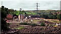
New Reddyshore Brow Housing in 1998
Pile driving was needed on the former mill/chemical works site latterly known as Grove Works
Image: © Kevin Waterhouse
Taken: Unknown
0.15 miles
5
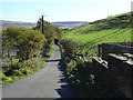
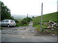
Track (footpath) off Calderbrook Road
Towards Whitfield.
Image: © JThomas
Taken: 18 Oct 2018
0.15 miles
7
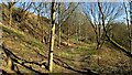
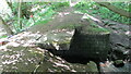
Footpath in Shop Wood
The warning notice is for Protruding Ground Stabilisation Rods. These were required for new housing above an old tipping site. Shop Wood is one of several community woods established in Littleborough
Image: © Kevin Waterhouse
Taken: 26 Feb 2019
0.15 miles
8
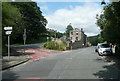
The junction of Barnes Meadows with Todmorden Road, Calderbrook
The road name looks modern, and a look at the 1:2500 map on 1893 shows only a track. The 1910 edition shows the road, without a name, only as far as the newly built school. Calderbrook Terrace also appears on that map.
Image: © Humphrey Bolton
Taken: 24 Jul 2017
0.16 miles
9
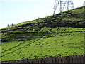
Hill Top Farm
The farm sits above Hill Top Colliery remains which extend along Calderbrook Road. The footpath going up the hillside in the centre of this view passes a small concrete shed that may be part of the colliery remains
Image: © Kevin Waterhouse
Taken: 22 May 2017
0.16 miles
10
Old Slab Bridge on River Roch
This old bridge now has a new Environment Agency bridge built above it as their access point to a flood defence scheme
Image: © Kevin Waterhouse
Taken: 21 May 2020
0.17 miles