IMAGES TAKEN NEAR TO
Gale Close, LITTLEBOROUGH, OL15 9EJ
Introduction
This page details the photographs taken nearby to Gale Close, OL15 9EJ by members of the Geograph project.
The Geograph project started in 2005 with the aim of publishing, organising and preserving representative images for every square kilometre of Great Britain, Ireland and the Isle of Man.

There are currently over 7.5m images from over14,400 individuals and you can help contribute to the project by visiting https://www.geograph.org.uk
Image Map
Images are licensed for reuse under creativecommons.org/licenses/by-sa/2.0
Notes
- Clicking on the map will re-center to the selected point.
- The higher the marker number, the further away the image location is from the centre of the postcode.
Image Listing (31 Images Found)
Images are licensed for reuse under creativecommons.org/licenses/by-sa/2.0
Image
Details
Distance
1
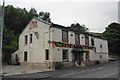
Former pub at Gale
This outlet on Todmorden Road now provides a wide range of takeaway food.
Image: © Bill Boaden
Taken: 20 Jul 2013
0.06 miles
2
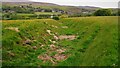
Sunken Lane from Whitfield Farm
Track of old lane linking Whitfield Farm with Town House Carriage Drive
Image: © Kevin Waterhouse
Taken: 22 May 2017
0.09 miles
3
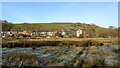
Flood Plain of River Roch
This rough pasture is between the railway embankment and the River Roch. The housing is on Todmorden Road at Gale. The Environment Agency have since developed the next section of land upstream as a designated flood plain
Image: © Kevin Waterhouse
Taken: 19 Nov 2017
0.11 miles
4
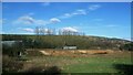
Tree Clearance on Railway Embankment
View from Rochdale Canal Towpath near Bent House Bridge
Image: © Kevin Waterhouse
Taken: 14 Feb 2016
0.18 miles
5
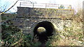
Railway Underpass
The east portal of the underpass for the track from Bent House to Gale is probably the original Manchester & Leeds Railway build around 1840. The railway was subsequently widened on the west side
Image: © Kevin Waterhouse
Taken: 19 Nov 2017
0.18 miles
6

Railway
The railway line between Littleborough and the Summit tunnel.
Image: © David Dixon
Taken: 20 May 2010
0.18 miles
7
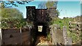
Subway under Manchester - Leeds Railway
This subway was always flooded until new drains were installed in the field below the Rochdale Canal at this time.
Image: © Kevin Waterhouse
Taken: 4 May 2017
0.19 miles
8
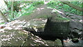
Old Slab Bridge on River Roch
This old bridge now has a new Environment Agency bridge built above it as their access point to a flood defence scheme
Image: © Kevin Waterhouse
Taken: 21 May 2020
0.20 miles
9
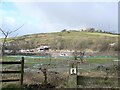
Construction site, flood alleviation scheme, Gale
VolkerStevin are constructing a flood defence scheme to reduce the risk of flooding across Rochdale and Littleborough. This will include a new flood storage area at Gale, as well as raised walls and improvements to culverts and bridges along four brooks. Work started in 2021. The next phase of the scheme involves the construction of a storage reservoir at Gale, just off Todmorden Road, and measures to improve water flow and flood defences along the River Roch and its tributaries.
Image: © Christine Johnstone
Taken: 1 Feb 2022
0.20 miles
10
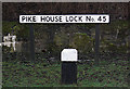
Pike House Lock no 45 Rochdale Canal
Name sign on the east bank of the canal. The position of the sign can be seen on this photograph http://www.geograph.org.uk/photo/404729
Image: © michael ely
Taken: 28 Jan 2010
0.21 miles