IMAGES TAKEN NEAR TO
Great Howarth, ROCHDALE, OL12 9HQ
Introduction
This page details the photographs taken nearby to Great Howarth, OL12 9HQ by members of the Geograph project.
The Geograph project started in 2005 with the aim of publishing, organising and preserving representative images for every square kilometre of Great Britain, Ireland and the Isle of Man.

There are currently over 7.5m images from over14,400 individuals and you can help contribute to the project by visiting https://www.geograph.org.uk
Image Map
Images are licensed for reuse under creativecommons.org/licenses/by-sa/2.0
Notes
- Clicking on the map will re-center to the selected point.
- The higher the marker number, the further away the image location is from the centre of the postcode.
Image Listing (18 Images Found)
Images are licensed for reuse under creativecommons.org/licenses/by-sa/2.0
Image
Details
Distance
1
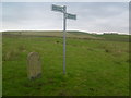
Rochdale Boundary Stone
old boundary stone with missing boundary plate.
Image: © Alan Valentine
Taken: 6 Oct 2008
0.13 miles
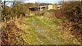
2
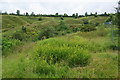
Footpath to Ring Lows Lane
Here leaving Buckley Lane. The lumpy nature of the far bank of the brook reflects past industrial activity.
Image: © Bill Boaden
Taken: 20 Jul 2012
0.18 miles
3
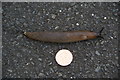
Big slug
Compared with a 2p coin. I'm not claiming a record, just that the damp summer has encouraged many large specimens like this.
Image: © Bill Boaden
Taken: 20 Jul 2012
0.18 miles
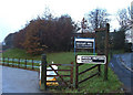
4
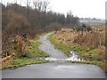
Buckley Lane (now footpath)
Heading north Buckley Lane, beyond its junction with Buckley Road and Rydings Road, is now cobbled and is a footpath closed to traffic. Rydings Road now carries road traffic north beyond this point and is signposted as private road closed to pedestrians.
Image: © Peter Thwaite
Taken: 5 Feb 2010
0.19 miles
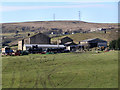
5
Birchen Head Farm
Marked as a footpath but no obvious continuation through the farm
Image: © Kevin Waterhouse
Taken: 25 Mar 2022
0.19 miles
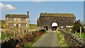
7
Buckley Hall Prison, Rochdale
An attractive entrance to this Young Offenders' Institution off Buckley Lane. The gate in the foreground is not the prison gate.
Image: © michael ely
Taken: 10 Dec 2005
0.20 miles
8
The continuation of Buckley Lane
It is quite clear that vehicles cannot go straight ahead along the route of Buckley Lane. However pedestrians are not allowed to go up the road to the right. Is it just because they didn't want to spend money on a pavement?
Image: © Bill Boaden
Taken: 20 Jul 2012
0.20 miles
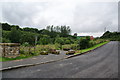
9
Rydings Road (original)
The cobbled road crosses Buckley Brook on this stretch. A new private Rydings Road serves Casey Group HQ which is at the top of this view
Image: © Kevin Waterhouse
Taken: 25 Mar 2022
0.22 miles
10
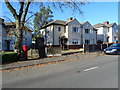
Houses on Wardle Road, Wardle
Showing position of Postbox No. OL12 137.
See Image] for postbox.
Image: © JThomas
Taken: 18 Oct 2018
0.23 miles