IMAGES TAKEN NEAR TO
Buckley View, ROCHDALE, OL12 9EB
Introduction
This page details the photographs taken nearby to Buckley View, OL12 9EB by members of the Geograph project.
The Geograph project started in 2005 with the aim of publishing, organising and preserving representative images for every square kilometre of Great Britain, Ireland and the Isle of Man.

There are currently over 7.5m images from over14,400 individuals and you can help contribute to the project by visiting https://www.geograph.org.uk
Image Map
Images are licensed for reuse under creativecommons.org/licenses/by-sa/2.0
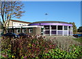
Notes
- Clicking on the map will re-center to the selected point.
- The higher the marker number, the further away the image location is from the centre of the postcode.
Image Listing (29 Images Found)
Images are licensed for reuse under creativecommons.org/licenses/by-sa/2.0
Image
Details
Distance
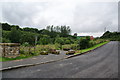
1
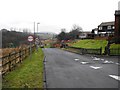
Buckley Lane
Looking north up Buckley Lane from its junction with Buckley View. Further north, some roads may have been realigned with Rydings Road replacing the upper part of Buckley Lane for road traffic and that part of Buckley Lane now being a footpath:
Buckley Lane (footpath part) http://www.geograph.org.uk/photo/1699873
Note: Buckley Lane is not to be confused with the nearby Buckley Farm Lane http://www.geograph.org.uk/photo/1840015
Image: © Peter Thwaite
Taken: 5 Feb 2010
0.10 miles
2
Cottages, Buckley Farm Lane, Rochdale, Lancashire
A 1973 view at the same place as the 1951 photograph.
Image: © Dr Neil Clifton
Taken: 3 Sep 1973
0.12 miles
3
Buckley Farm Lane, Rochdale, Lancashire
In the 15 years that have elapsed since my 1951 photograph, the appearance of Buckley Farm Lane has changed considerably. It now presents as a modern motor road, with metalled surface and raised footpath. Only the cottages remain as a link with the previous picture.
Image: © Dr Neil Clifton
Taken: 17 Aug 1966
0.12 miles
4
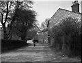
Buckley Farm Lane, Rochdale, Lancashire
At the time of this photograph, (1951), Buckley Farm Lane still presented a remarkably rural appearance, with large cobbles and absence of any footway. The old man, possibly on his way for his lunchtime 'pint', adds to the sense of an England that has now passed away.
Amazingly, well over 60 years after the photograph was taken, the identity of the senior citizen has emerged. He is Isaac John Tonks, and was on his way to meet his wife to help her carry her shopping home. I received this information from Mr. Tonks' greatgranddaughter.
Image: © Dr Neil Clifton
Taken: 11 May 1951
0.12 miles
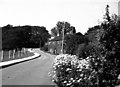
5
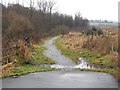
The continuation of Buckley Lane
It is quite clear that vehicles cannot go straight ahead along the route of Buckley Lane. However pedestrians are not allowed to go up the road to the right. Is it just because they didn't want to spend money on a pavement?
Image: © Bill Boaden
Taken: 20 Jul 2012
0.12 miles
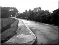
6
Buckley Lane (now footpath)
Heading north Buckley Lane, beyond its junction with Buckley Road and Rydings Road, is now cobbled and is a footpath closed to traffic. Rydings Road now carries road traffic north beyond this point and is signposted as private road closed to pedestrians.
Image: © Peter Thwaite
Taken: 5 Feb 2010
0.13 miles
7
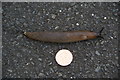
Big slug
Compared with a 2p coin. I'm not claiming a record, just that the damp summer has encouraged many large specimens like this.
Image: © Bill Boaden
Taken: 20 Jul 2012
0.14 miles
8
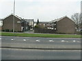
Rhodes Street, Smallbridge
Modern terraced housing just off the main Halifax Road (A58).
Image: © Peter Whatley
Taken: 25 Mar 2011
0.14 miles
10
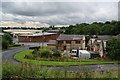
Old and new factory units in Hamer Vale
Part of Buckley Road Industrial Estate. Looking down from Buckley Lane.
Image: © Bill Boaden
Taken: 20 Jul 2012
0.16 miles