IMAGES TAKEN NEAR TO
Fern Hill Lane, ROCHDALE, OL12 6BW
Introduction
This page details the photographs taken nearby to Fern Hill Lane, OL12 6BW by members of the Geograph project.
The Geograph project started in 2005 with the aim of publishing, organising and preserving representative images for every square kilometre of Great Britain, Ireland and the Isle of Man.

There are currently over 7.5m images from over14,400 individuals and you can help contribute to the project by visiting https://www.geograph.org.uk
Image Map
Images are licensed for reuse under creativecommons.org/licenses/by-sa/2.0
Notes
- Clicking on the map will re-center to the selected point.
- The higher the marker number, the further away the image location is from the centre of the postcode.
Image Listing (5 Images Found)
Images are licensed for reuse under creativecommons.org/licenses/by-sa/2.0
Image
Details
Distance
1
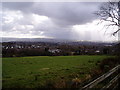
Rowan Close, Rochdale
View of houses in Rowan Close and Stonehill Road from Fern Hill. The 'Seven Sisters' tower blocks can be seen in the distance, with the Pennines and Peak District beyond.
Image: © ethics girl
Taken: 3 Mar 2008
0.14 miles
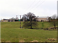
2
Rooley Moor Road
Looking towards Catley Lane Head.
Image: © David Dixon
Taken: 3 Mar 2010
0.15 miles
3
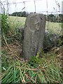
Old Guide Stone by Rooley Moor Road, near Catley Lane Head
Guide Stone by the UC road, in parish of Rochdale (Rochdale District), Catley Lane Head, 30m North of last house (No. 607) in Rooley Moor Road.
Surveyed
Milestone Society National ID: LA_XROC01
Image: © Milestone Society
Taken: Unknown
0.16 miles
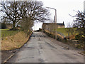
4
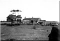
Brown Hill Farm
Rooley Moor Road, Lanehead.
Image: © David Dixon
Taken: 3 Mar 2010
0.16 miles
5
White Lees, near Norden, Rochdale, Lancashire
This stone farmhouse probably dates from the early eighteenth century.
Image: © Dr Neil Clifton
Taken: 24 May 1950
0.22 miles