IMAGES TAKEN NEAR TO
Slough Lane, LONDON, NW9 8XH
Introduction
This page details the photographs taken nearby to Slough Lane, NW9 8XH by members of the Geograph project.
The Geograph project started in 2005 with the aim of publishing, organising and preserving representative images for every square kilometre of Great Britain, Ireland and the Isle of Man.

There are currently over 7.5m images from over14,400 individuals and you can help contribute to the project by visiting https://www.geograph.org.uk
Image Map
Images are licensed for reuse under creativecommons.org/licenses/by-sa/2.0
Notes
- Clicking on the map will re-center to the selected point.
- The higher the marker number, the further away the image location is from the centre of the postcode.
Image Listing (105 Images Found)
Images are licensed for reuse under creativecommons.org/licenses/by-sa/2.0
Image
Details
Distance
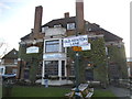
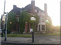
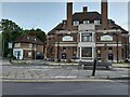
4
The Green Man, Kingsbury
Pub on Slough Lane, London NW9.
Image: © JThomas
Taken: 3 Aug 2019
0.04 miles
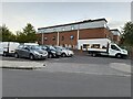
6
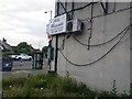
The side of Chilli Massala restaurant on Kingsbury Road
Image: © David Howard
Taken: 30 May 2019
0.04 miles
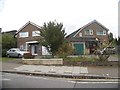
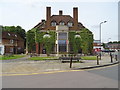
7
The Green Man pub on Slough Lane, Kingsbury
Image: © David Howard
Taken: 18 Aug 2022
0.05 miles
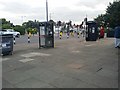
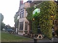
8
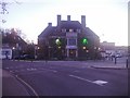
The Green Man pub on Slough Lane, Kingsbury
It was always called the Green Man, then it changed its name a couple of times, and now it is the Green Man again.
Image: © David Howard
Taken: 30 Oct 2013
0.05 miles